|
|
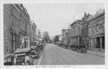
tazewellmain1926.jpg527 viewsThis is a 1926 view of Tazewell's Main Street.
|
|

washmills1914.jpg527 viewsThis is from a 1914 postcard.
|
|

100_1831.jpg527 viewsPhoto November 1, 2006 by Jeff Weaver.
|
|

Tumbling Cove - Clinch Mountain Wildlife Management Area527 viewsPhoto by Jeff Weaver, March 30, 2007
|
|

Green Cove - Creek Junction Trestle527 viewsMYRL DUNHAM / CREEK JUNCTION TRESTLE / CREEPER TRAIL BETWEEN GREEN COVE AND TAYLOR'S VALLEY, VA. Courtesy of Don Smith dsmith1043@comcast.net
|
|

abingdon1846.jpg526 viewsThis sketch of Abingdon was first published in Henry Howe's 1846 Description of Virginia.
|
|

graysonseal.jpg526 viewsEnough said.
|
|

100_1427.jpg526 viewsPhoto April 2, 2006 by Jeff Weaver
|
|

100_1611.jpg526 viewsPhoto April 19, 2006 by Jeff Weaver.
|
|

plasterco2.jpg526 viewsThis is a circa 1905 photo of the Plaster works at Plasterco.
|
|

100_1748.jpg526 viewsThis is the easterly view from the Sugarlands overlook in Grayson Highlands State Park. Photo October 18, 2006 by Jeff Weaver.
|
|

apphospital.jpg526 viewsThis is a 1930s postcard view.
|
|
| 4754 files on 397 page(s) |
 |
|
|
|
|
|
|
|
|
331 | |
|
|
|
|
|
|
|
|