Natural Resources of New River Valley


-
 The best recorded observations for the Upper New River Valley were made by Asa Gray in July 1841. Fortunately for the modern researcher, he recorded his observations, part of which are reprinted below. These observations originally appeared in the American Journal of Sciences and Arts, volume 42, number 1, 1842.
Notes of a Botanical Excursion To the Mountains of North Carolina
On the 2d of July [1841] we continued our journey (eleven miles) to Jefferson or Ashe Court House, a hamlet of twenty or thirty houses, and the only village in the county. Intending to make this place our headquarters while we remained in the region, we had the good fortune to find excellent accommodations at the house of Colonel [George] Bower, who evinced every disposition to further our inquiries, and afforded us very important assistance. We may remark indeed, that during our residence amongst the mountains we were uniformly received with courtesy by the inhabitants; who for the most part lacked the general intelligence of our obliging host at Jefferson, and could scarcely be made to comprehend the object of our visit, or why we should come from a distance of seven hundred miles to toil over the mountains in quest of their common and disregarded herbs. Curiosities as we were to these folks, their endless queries had no air of impertinence, and they entertained us to the best of their ability, never attempting to make unreasonable charges…
We botanized for several days upon the mountains in the immediate neighborhood of Jefferson, especially the Negro Mountain, which rises abruptly on one side of the village, the Phoenix Mountain, a sharp ridge on the other side, and the Bluff, a few miles distant in westerly direction. The altitude of the former is probably between four and five thousand feet above the sea; the latter is apparently somewhat higher. They are all composed on Mica-slate; and we should remark that we entered upon a primitive region immediately upon leaving the Valley of Virginia. The mountain sides, though steep or precipitous, are covered with a rich and deep vegetable mould, are heavily timbered, chiefly with Chestnut, White Oak, the Tulip-tree, the Cucumber tree, and sometimes the Sugar Maple. Their vegetation presents so little diversity, that it is for the most part unnecessary to distinguish particular localities. Besides many of the plants already mentioned, and a very considerable number of northern species which we have not room to enumerate, we collected or observed on the mountain sides, Clematis Viorna in great abundance; Tradescantia Virginica; Ris cristata in fruit; Hedyotis (Amphiotia) purpurea, which scarcely deserves the name, since the flowers are commonly almost white; Phlox paniculata? Aristolochia Sipho, without flowers or fruit; Ribes Cynosbati, rotundifolium,… prostratum,… Allium cernuum and tricoccum; Galax aphylla; ligusticum actaeifolium, [ramps] the strong-scented roots of which are eagerly sought and eaten by boys and hogs; The Ginseng, here called “sang” (the roots of which are largely collected, and sold to the country merchants when fresh for about twelve cents per pound, or when dry for triple that price); Menziesia globularis, mostly in fruit; and the showy Azalea calendulacea [honeysuckle or flame azalea], which was also out of flower, except in deep shade.
Gray continued, listing various Latin names for the local plant life. Others have estimated that there are over 1000 species of plants in the Upper New River Valley, some unique to the area. Other species found in the area are out of place for the latitude. Red spruce and balsams were and are found in the region, though normally native to Canadian latitudes.
Other common species are Laurels, which adds vivid color in the mountains in early spring. Lily’s of the Valley add their white and native wild flowers add reds, yellows and blues to the forest floors. Native plants, especially flowers, of the Upper New River and especially resistant to cultivation, which makes some of them endangered species. Adding to the endangered status is extensive logging of the forest which has destroyed much of the habitat of the native flora and fauna.
Lewis Preston Summers reported in 1901 the following notes about White top Mountain by Charles Coal:
This is a peak in the Appalachian range, here more familiarly known by the local name of Iron Mountain, and head the point where the three States of Virginia, Tennessee and North Carolina all unite at a common corner. It is about twenty miles from Abingdon the way the crow flies, though perhaps thirty by the intricate bridle paths through intervening mountains, by which it is approached. Until within a few years comparatively, owing to its inaccessibility, it was almost in its primitive state, and visited only by hunters and trappers, and here and there a “squatter,” who may have fled to it fastness to evade those penal enactments which a certain class of men in most communities deem oppressive. It is some 5,000 feet high from base to summit, and upwards of 6,000 feet above the level of the sea. Its summit is a vast field comprising from 300 to 500 acres, without a tree or shrub, and covered with a luxuriant growth of wild grass resembling that of our northwestern prairies, which is highly nutritious and cropped with insatiable avidity by vast heard os stock driven from the neighboring settlements to graze and fatten. During the months of May and June, this field, as well as a large portion of the wooded parts of the mountain, is gorgeously carpeted with wild flowers of every imaginable hue, and so fragrant that their perfume is often wafted a considerable distance on the wings of the wind, which sometimes sweeps across the broad fields like the dying throes of a hurricane, with fitful shrieks of wild and melancholy music.
Bordering this natural field are great numbers of native gooseberry and currant bushes, which yield their acrid fruits in never-failing abundance, and the wild leopard lily, springing from its rocky bed, sways to and fro and scatters its rich perfume as the blast sweeps by.
Upon the very summit, various springs of ice-cold water gush from the rocks and leap down the declivities, babbling their wild music as they disappear among the magnificent rhododendrons and the dazzling crimson of the Indian pink. These water are so pure and light that they never oppress, no matter how freely the thirsty visitor may quaff them.
The field above referred to is bordered by a very singular as well as very beautiful growth of timber, known in that region by the name of Lashorn. Some of these trees grown to an immense height, but generally are not more than from thirty to fifty feet high, and, what is very remarkable, where not crowded they are perfectly flat on top, spreading our to a diameter of from fifteen to thirty feet. It is a species of, and very much resembles, Norway spruce, an ornamental tree often found in the yards of our more elegant city residences. The Lashorn of White Top mountain is peculiar to that locality, and of the thousands that have been transplanted, not one have ever been known to grow, though some have lived several years…. Where the forest of this singular and beautiful growth is dense there is no undergrowth, the trees limbless to the height of forty or fifty feet, the tops intermingling covered with a carpet of lichen moss which feels to the tread as soft and elastic as a sponge. During the summer months those trees are literally alive with snow birds, the little creatures congregating here in millions to build their habitations and rear their young.
Notwithstanding the romantic beauty of this grand elevation, and the exhilarating effects of the highly rarified atmosphere upon the system, hundreds and thousands have lived and died within sight of it without ever having paid it a visit. The reason for this have been the difficulty of access, want of accommodations in the vicinity, and the mere cattle paths by which it is approached through deep and intricate gorges, over steep foot-hills, and through almost impenetrable laurel jungles, sometimes infested by bears, wolves, wild-cats and rattlesnakes. There are but few of these “varmints” there now.
The view from the summit of the White Top is grand beyond description or even conception. Looking toward the south, you have within the scope of vision, stretching away from east to west, the Blue Ridge, which in the dim distance looks like an azure band bordering the horizon, with here and there a tall peak hiding its head in the clouds. To the east, mountain piled upon mountain meets the view, their gentler slopes in places dotted with “clearings” and a column of smoke, here ascending and there lying in long folds along the mountain side, denoting the rude habitation of he ruder “squatter.” Looking toward the north you have the grand old Cumberland range, the barrier that divides the “Dark and Bloody Ground” from the Old Dominion, as if swelling up from an ocean of green, and struggling to lift itself above the vapor that hangs lazily upon its sides. To the west the view, though less imposing, is not less beautiful. You have before you the broad valley of the Holston, which, although diversified with hill and dale, bold promontories and pine-clad ridges, still from the altitude from which you look our upon it, has the appearance of a vast sea dotted with picturesque islands. In the distance the spires and tin roofs of the town of Abingdon glisten in the sunlight, large plantations look like blankets spread our in the forest, and at intervals, as it dashes out from behind a bluff, or winds its way through a green pasture, may the White Top Fork of Laurel be seen, like a serpentine thread of silver, its sparkling waters shimmering like diamonds among the foliage and wild flowers upon its bank.
The writer of this has enjoyed the luxury of many a magnificent scenes in his wanderings, but has never seen that from the summit of the White Top excelled, or even equaled. He was there on one occasion when a storm came riding on the blast more than a thousand feet below where a company of gentlemen were standing. The whole valley was shrouded as with a pall. The deep- toned thunder bellowed below, preceded by brilliant flashes of lightning, illuminating the dark bosom of the cloud. The scene was awfully grand, and so far transcends the powers of mortal description, that he would no dare attempt it.
Observations on the wildlife were made by Charles Coal in his account of the life of the famous Wilburn Waters. Other notations about “varmints” are interspersed throughout the records of Ashe and Grayson’s County Courts. In the early days of settlement wolves were abundant and the counties offered bounties for each wolf scalp brought in. Many of the families of the region found this practice a source of hard cash in a nearly cash-less society. Some of the foxier of the regions inhabitants only killed young wolves, leaving the older, more dangerous animals to roam and breed a new crop of wolf pups to be killed the following year.
Other stories abound in the oral tradition about panthers, bears, wild cats, bob cats and other predatory animals which were considered a bother to the settler’s cattle and sheep. Other animals were in fact more destructive to crops than the predatory animals, such as raccoons, opossums and the like, which were largely ignored by the settlers and were never exterminated like the large game animals.
Numerous writers about the physical attributes of the region have remarked that the inhabitants have become part of the landscape. The symbiotic relationship of man and nature have given the love of land rarely found elsewhere, yet the residents of Appalachia can be and often have been guilty of gross neglect of their environment. Fortunately, the residents of the Upper New River Valley are among the least guilty of crime against nature. Even the environmental problems in the Upper New River Valley are the result of ignorance of good land use policy or economic necessity. Care must be taken to preserve the environment or it follows that the uniqueness of the region will, in large part, be lost for ever. The enduring rural nature of the area makes comprehensive land-use planning difficult, and the key to successful preservation of the natural beauty of the area lies with the common sense of the people of the area, as well as the leaders of the counties, state and nation to develop the resources of the region.
-
The climate of the Upper New River Valley significantly contributed to the delay in settlement of the valley. Moravian Bishop Gottlieb Augustus Spanenberg, one of the first white men to extensively explore the valley, noted in his diary many of his observations. A key reason that he did not bring his planned colony to the Upper New River Valley was climatic, the other was the lack of a level enough tract for the 100,000 acres he was looking for. Spanenberg noted that the winter was fiercely cold, and this was a man raised in Central Europe and knew cold. It was so cold, according to the good Bishop, that water froze beside the fire. Instead of the New River his colony settled at what is now Forsythe County, North Carolina. His Moravians founded the thriving Salem settlement, now incorporated into Winston-Salem.
Other more scientific measurements seem to indicate that the winter of 1752-3 was an anomaly, however the measurements reveal that the area does suffer more than the surrounding country from winter cold and wind. The average temperature averages at least 10 degrees lower than the Piedmont, less than 50 miles to the east. The Valley also averages 5 degrees cooler than the nearby valleys that run northeast-southwest through Virginia and into Tennessee. Mountain tops and ridges away from the larger streams often are even colder in winter or cooler in summer. The last frost in spring is early enough to allow most crops to mature before the first frost of the fall. Tradition indicates that the winter of 1883 was exceptionally cold, probably as a result of the Krakatoa volcanic eruption in the South Pacific. In the year that followed this catastrophe half a world away there was frost every month of the year, in fact 1883 was known as the year without a summer, but the effects were felt far and wide, not just in the New River Valley. Crops this year failed and some of the families of the valley suffered, having to consume their seed stocks, causing great hardship in a time in which there was virtually no money to buy replacement supplies. Arthur Fletcher noted, that there were very big snows in 1838, 1886, 1888 and 1959. He further noted, “The big snow of 1886 was deep enough to cover all fences and was on the ground so long that Ashe County’s deer population, along with other game was almost completely destroyed.” Modern records indicate that the region receives an average annual snow fall of about 25 inches. This snow fall is vital to replenishing the water table or the Valley.
Despite the problems with temperature, the region enjoys some advantages the piedmont sections do not – abundant rainfall in spring, summer and autumn and snowfall in winter. This precipitation has let the valley avoid the ravages of summer droughts suffered in the piedmont. There are of course exceptions to these generalizations, one being the drought of 1862, which was a severe burden on the infant Confederate States of America, which needed abundant crops that year to supply the armies in the field. Rain and snow have caused most of the still talked about natural disasters which permeate the folk-lore of the valley. The valley’s great floods of 1833, 1916, 1940 and 1990 were the results of hurricanes on the Atlantic coast which came inland. Other spring seasons have had heavy rainfalls, enough so to cause flash-floods, some of which have taken the lives of valley residents. Flash floods have taken more lives than any other type natural disaster in the area. Another key advantage to life in the Upper New River Valley is the shelter the mountains provide. The region is relatively free from high winds and there has never been a tornado in the Upper New River Valley in its recorded history.
According to Fletcher, this valley “…is sunny. The total amount of sunshine varies from about 53 percent of the total possible in winter to about 70 percent in the fall. The average for the year is close to 61 percent…. the fair day average is 165, partly cloudy, 100 and cloudy 100.”
-
As you may be aware, the timber industry was the principal employer in the Upper New River Valley in the early 20th century. Logging and sawmilling continue to the present day at a smaller scale in the area. Prior to that, the forest gave the settlers products to build their homes; habitat for game; food, and recreation. This is intended to be a listing of the common species of forest trees found in this geographic area.
Trees of Upper New River Valley Common Name Latin Name White Pine Pinus Strobus Short-leaf Pine Pinus echinata Scrub, Jersey or Virginia Pine Pinus virginiana Tamarack (or common larch) Larix americana Hemlock Tsuga canadensis Balsam Fir (Fraser Fir) Abies balsama Arbovitae Thuja occidentalis Red Cedar Juniperus virginianan Black Willow Salix nigra Trembling Aspen Populus tremuloides Large Toothed Aspen Populus grandidentata Carolina Poplar Populus deltoidea Butternut Jaglans cinera Black walnut Juglans nigra Shellbark Hickory Hicoria ovata Mockernut Hickory Hicoria alba Blue Beech Carpinas caroliniana Ironwood Ostrya virginiana Black Birch Betula lenta Yellow Birch Betula lutea Red Birch Betula nigra Paper Birch Betula papyrifera American Beech Fagus americana Chestnut Castanea dentata Chinquapin Castanea pumila White Oak Quercus alba Chestnut Oak Quercus prinus Red Oak Quercus rubra Pin Oak Quercus palustris Scarlet Oak Quercus coccinea Black Oak Quercus velutina American Elm Ulmus americana Slippery Elm Ulmus fulva Hackberry Celtis occidentalis Mulberry Morus rubra Cucumber Tree Magnola acuminata Yellow Poplar Liriodendron tulipi fera Sassafras Sassafras sassafras Karst Witch Hazel Hamamelis virginiana Black Gum Nyssa sylvatica Marsh Sycamore Platans occidentalis American Crab Apple Malus coronaria Service Berry (Sarvis) Amelanchier canadensis Cockspur thorn Crataegus crus-galli Dotted Thorn Crataegus punctata Wild Cherry Prunus serotina Wild Plum Prunus americana Black Locust Robinia pseudacacia Red Bud Cercis canadensis Dwarf Sumac Rhus copallina American Holly Ilex opaca Mountain Maple Acer spicatum Sugar Maple Acer saccharum Marsh Silver Maple Acer saccharinum Red Maple Acer rubrum Sweet Buckeye Aesculus octandra Marsh. Flowering Dogwood Cornus florida Rhododendron Rhododendron maximum Mountain Laurel Kalmia latifolia Sourwood Oxydendrum aboreum White Ash Fraxinus americana Black Haw Viburnum prunifolium -
The Warm Springs are in Bath County, about 170 miles, nearly west on the great spring route from Staunton. They are situated in a delightful valley, between lofty hill ranges. Fine views are opened all about on the Warm Spring Mountain. From the “Gap,” where the road crosses, and from “the Rock,” 2,700 feet above tide-water, the display is deservedly famous.
The Bath Alum Springs are at the eastern base of the Warm Spring Mountain, five miles east of the Warm Springs, 47 miles east of the White Sulphur and 45 miles west of Staunton. The valley of the Bath Alum is a cozy glen of 1,000 acres, shut in, upon the east, by McClung’s Ridge; on the southeast by Shayer’s Mountain; on the west by the Piney Ridge; and on the southwest by Little Piney.
Hot Springs–Five miles removed from the Warm Springs at the intersection of two narrow valleys are the Hot Springs. The scenery here, though very agreeable as is that of all the region round is not especially striking. Healing Springs, Bath County–These thermal waters lie in a pleasant valley of eight or ten miles extent between the Warm Spring Mountain on the east and the Valley Mountain on the west. In the neighborhood is a fine cascade.
The Rockbridge Alum Springs are in Rockbridge County, on the main road from Lexington to Warm Springs, 17 miles from the first and 23 miles from the second point. The Valley in which they are found lies below the North Mountain on the east and the Mill Mountain on the west.
The Fauquier White Sulphur, in Fauquier County are 40 miles from Fredericksburg and 132 miles from Richmond. They are quickly reached by rail from either point.
Jordan’s White Sulphur. These Springs are in Frederick County, five miles from Winchester, and one mile and a half from Stephenson Depot on the Winchester and Potomac Railway. Distance from Harpers Ferry 28 miles.
The Capon Springs are 23 miles southwest of Winchester at the base of North Mountain. Take the Baltimore and Ohio Railway from Baltimore to Harper’s Ferry, 82 miles; thence the Pomotac and Winchester 32 miles to Winchester; thence by stage; or take the Orange and Alexandria road from Alexandria 27 miles to Manassas Station and the Manassas Gap Railway 61 miles more to Strasburg.
The Shannondale Springs are in Jefferson County, five miles and a half from Charlestown, a point on the railway from Harper’s Ferry to Winchester. Distance from Charlestown from Harper’s Ferry 10 miles; from Baltimore 92 miles.
The Berkely Springs, Morgan County are two miles and a half from the Sir John’s Run a point on the Baltimore and Ohio Railway, 100 miles west of Baltimore. This is a very ancient and distinguished resort, esteemed and frequented by Washington before the Revolution. Commodious hotels.
Dibrell’s Spring is on the main road from Lynchburg to the White Sulphur 19 miles west, by a direct road from the Natural Bridge. It is in the extreme northwestern part of Botetourt County, 30 miles east of the Alleghanies, and at the base of Gordon Mountain.
The Alleghany Springs are in Montgomery County, on the south fork of the Roanoke River, 10 miles east of Christiansburg on the Virginia and Tennessee Railway. From Richmond to Christiansburg 210 miles west; from Lynchburg 36 miles.
New London Alum is in the County of Campbell, 10 miles southwest of Lynchburg.
Grayson’s Sulphur Springs are west of the Blue Ridge in Carroll County, 20 miles south of Wytheville on the New River–a region of remarkable natural beauty.
Pulaski Alum Spring, in Pulaski County, on Little Water Creek, 10 miles from Newbern and seven miles in a direct line from the Virginia and Tennessee Railway.
The Hugenot Springs is a watering place in Powhatan County, 17 miles from Richmond. Take the Richmond and Danville Railway to the Springs station about 10 miles, thence by good omnibus or stages. A pleasant excursion from Richmond.
There are many other mineral fountains in Virginia, discovered and undiscovered. We have mentioned only those of much resort.
-

Western Virginia 1774
Map discovered in the National Archives in the Records of the Continental Congress by Billy J. Markland, who provided this electronic copy.
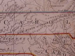
Map State of Franklin, 1792, Note the boundary at the Blue Ridge.
Regional Maps ca. 1920
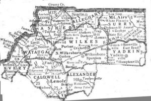
Northwest North Carolina Map, ca. 1920
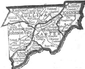
Northeast Tennessee Map, ca. 1920