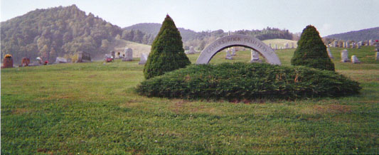
Comers Rock Cemetery
Grayson County, Virginia
Location: West of Elk Creek on Comers Rock Rd (Rt 658) in Comers Rock, Grayson County , VA
Directions: From Independence go north on Elk Creek Pky (US 21) about 9.5 miles to junction with Comers Rock Rd (Rt 658). Head west 5 miles. Cemetery is well marked and north of the road.
GPS Coordinates: N36.745163 W81.242844
Surveyed by: Susan Taylor Woodson; updated in July 2006 by Peggy Cornett Greene and Nancy Cornett Swetland and by Rich and Ginger Ballard Dec 2008.
Comments: Cemetery is well kept and easily accessed.The land for this cemetery was donated to the Mt. Zion Church by James Cornett (1810 – 1871). The first burial was his wife Sarah C. Boyer Cornett (1807 – 1841).This cemetery is divided by the loop road through it into four sections. The Center section, the oldest and largest, is within the loop road. Newer sections are identified here as West, North, and East based on their positions relative to this loop road. Rows start at the south (lower) and west end, but in the center section it takes some imagination to identify “rows” and they may start or end in the middle of the area and meander back and forth on the hill. The center section was portioned into family plots that are multiple rows wide. It appears that position in the family plot takes priority over orderly rows. Unfortunately, it is not practical for us to list burials arranged by family plot.There are over 25 people reported to be buried in this cemetery for whom no marker has been found. Probably these are in unmarked graves but there may be reporting errors also.
| Row | Name | Birth | Death | Comments |
|---|---|---|---|---|
| Row 1 (First marker at south end of this row, on western side of central section, near top of hill.) | BOYER, John W. | 30 Nov 1923 | 9 Jan 1997 | SSgt U.S. Army World War II; double stone with next |
| Row 1 (First marker at south end of this row, on western side of central section, near top of hill.) | BOYER, Mary Rubie Cornett | 25 Mar 1927 | 9 Feb 2007 | [d/o William Hoyle & Percilla Parks Cornett] |
| Row 2 (Row commences about half-way up from southwest corner) | DELP, Robert M. | 13 Jan 1900 | 20 Apr 1988 | |
| Row 2 (Row commences about half-way up from southwest corner) | CORNETT, J[ewel] P. | 12 Jul 1923 | 5 Dec 2001 | U.S. Army Air Forces World War II; double stone with next |
| Row 2 (Row commences about half-way up from southwest corner) | CORNETT, Lois Wilson | 18 Nov 1928 | ||
| Row 2 (Row commences about half-way up from southwest corner) | CORNETT, Eugene Blake | 13 Dec 1913 | 21 Nov 2001 | [s/o Winter Forest & Effie Virginia Sutherland Cornett]; double stone with next |
| Row 2 (Row commences about half-way up from southwest corner) | CORNETT, Loetta Sutherland | 31 Oct 1919 | [Loetta Bell, d/o Marvin Chappell & Mamie A. Cornett Sutherland] | |
| Row 2 (Row commences about half-way up from southwest corner) | WAGNER, Larry David | 1 Mar 1941 | double stone with next | |
| Row 2 (Row commences about half-way up from southwest corner) | WAGNER, Eliza Kathleen "Kathy" Cornett | 22 Feb 1943 | ||
| Row 2 (Row commences about half-way up from southwest corner) | TAYLOR, Ralph Stephen | 7 Oct 1911 | 6 Dec 1983 | [s/o William Guy and Effie Cornett Taylor]; double stone with next |
| Row 2 (Row commences about half-way up from southwest corner) | TAYLOR, Virginia McCorkle | 21 Feb 1917 | 7 May 1998 | [nee McKorkle] |
| Row 2 (Row commences about half-way up from southwest corner) | CORNETT, Edd L. | [3 May] 1911 | [14 Apr] 1995 | [Edd Lee, s/o Foy and Letitia Belle Hackler Cornett]; double stone with next |
| Row 2 (Row commences about half-way up from southwest corner) | CORNETT, Mozelle S. | [14 May] 1914 | [20 Jul] 1974 | [d/o Elbert McDonald and Effie Caroline Keesling Steffey] |
| Row 2 (Row commences about half-way up from southwest corner) | GRUBB, James L. | 1875 | 1959 | stone sunken |
| Row 2 (Row commences about half-way up from southwest corner) | GRUBB, Drucy A. | [6 Apr] 1889 | 1964 | [Drucy Adeline, d/o Henry Albert and Frankie Elvira Parks Testerman; m1 Charles Foster Fielder, m2 James L. Grubb] |
| Row 2 (Row commences about half-way up from southwest corner) | HODGE, Robert W. | 8 Mar 1880 | 7 Aug 1959 | double stone with next |
| Row 2 (Row commences about half-way up from southwest corner) | HODGE, Mollie J. Robinson | 7 May 1892 | 30 Aug 1987 | |
| Row 2 (Row commences about half-way up from southwest corner) | CORNETT, Gayle H. | 22 Nov 1906 | 4 Jan 1990 | [Gayle Howard, s/o Stephen R. and Mary E. Burris Cornett; h/o Nina Elizabeth]; double stone with next |
| Row 2 (Row commences about half-way up from southwest corner) | CORNETT, Audrey H. | 12 Apr 1912 | 4 Apr 1964 | [Audrey W., d/o William W. and Etta V. Cornett Hines] |
| Row 2 (Row commences about half-way up from southwest corner) | HATFIELD, Maxine | [19 Jan] 1933 | [2 Dec] 1976 | [d/o Gayle H. and Audrey Hines Cornett] |
| Row 2 (Row commences about half-way up from southwest corner) | CORNETT, William Hoyle | 29 Mar 1894 | 12 Nov 1973 | [s/o John M. and Sarah Ann Livesay Cornett]; double stone with next |
| Row 2 (Row commences about half-way up from southwest corner) | CORNETT, Percilla Parks | 7 Nov 1896 | 5 Oct 1993 | [Martha Percilla, d/o Amos and Mary Sanders Parks] |
| Row 2 (Row commences about half-way up from southwest corner) | CORNETT, W. Herman | 23 Dec 1918 | 14 Dec 2002 | [William Herman, s/o William Hoyle & Percilla Martha Parks Cornett]; double stone with next |
| Row 2 (Row commences about half-way up from southwest corner) | CORNETT, Aldena B. | 8 Oct 1921 | [d/o John Bruce & Thelma Elizabeth Harrison Bedsaul] | |
| Row 2 (Row commences about half-way up from southwest corner) | CORNETT, Mary Kay | 29 Jan 1952 | 23 Nov 1960 | d/o Herman and Aldena Cornett |
| Row 2 (Row commences about half-way up from southwest corner) | CORNETT, Charles E. | 11 Nov 1873 | 20 May 1954 | [Charles Emory, s/o Hazel Creed & Amanda Emeline Cornett Cornett]; double stone with next |
| Row 2 (Row commences about half-way up from southwest corner) | CORNETT, Laura B. | 26 May 1878 | 20 Apr 1959 | [Laura Bell, d/o William Jasper & Mary Elizabeth Sutherland Roberts] |
| Row 2 (Row commences about half-way up from southwest corner) | CORNETT, Clarence W. | 8 Jan 1903 | 19 Jun 1982 | [Clarence Wysor, s/o Charles Emory & Laura Bell Roberts Cornett]; double stone with next |
| Row 2 (Row commences about half-way up from southwest corner) | CORNETT, Virgie Mize | 31 Oct 1902 | 5 Nov 1964 | [d/o Spariel Adam & Otie Watson Vaught Mize] |
| Row 3 | CATRON, Othie Berlin | 24 Nov 1907 | 18 Jul 1975 | [s/o William Dolph and Sarah Virginia Myers Catron]; double stone with next |
| Row 3 | CATRON, Mattie Eanes | 29 May 1908 | 21 Jan 1986 | [d/o James and Molly Kirby Eanes] |
| Row 3 | CORNETT, Lonnie O. | 4 Aug 1871 | 10 Apr 1945 | [Lonnie Orville, s/o Hazel Creed and Amanda C. Cornett]; double stone with next |
| Row 3 | CORNETT, Lucy A. | 11 Sep 1876 | 16 Dec 1959 | [d/o James P. and Sarah Eveline Delp Catron] |
| Row 3 | POOLE, Cebert M. | [23 Jan] 1885 | [18 Nov] 1947 | [s/o Wiley and Sarah Ann Cornett Poole]; double stone with next |
| Row 3 | POOLE, Myrtle A. | [11 Sep] 1887 | [16 Jan] 1975 | [d/o Stephen and Mary Jane Hackler Hall] |
| Row 3 | CARRICO, Levie Kenny | 5 Jan 1887 | 17 Aug 1950 | |
| Row 3 | CARRICO, Almedia E. | 29 Apr 1883 | 6 Oct 1948 | [d/o Enoch & Elizabeth Livesay; w/o William J. Carrico] |
| Row 3 | PARKS, Ellis W. | 24 Apr 1887 | 7 Aug 1956 | [William Ellis, s/o Zachariah Dailey and Lucinda Carrico Parks] |
| Row 3 | PARKS, Zina H. | 1 Oct 1892 | 26 Jun 1949 | [Zina Haden, d/o John M. and Sarah Ann Livesay Cornett; w/o William Ellis Parks] |
| Row 3 | HASH, Bessie F. | 25 Feb 1893 | 17 Oct 1950 | [d/o Ephraim and Martha Delp Fielder]; double stone with next |
| Row 3 | HASH, Allen J. | 28 Apr 1889 | 3 Jan 1963 | [s/o William Troy & Mary Mollie Haga Hash] |
| Row 3 | HACKLER, Alexander R. | [13 Mar] 1872/73 | [9 May] 1951 | [Alexander Rush, s/o Stephen Harvey and Mary Melvins Roark Hackler]; double stone with next |
| Row 3 | HACKLER, Mittie E. Wright | [14 Feb] 1879 | [22 Dec] 1969 | [Mittie Elizabeth, d/o Andrew Whaley and Josephine McGrady Wright] |
| Row 3 | CUNNINGHAM, John | 1882 | [27 Oct] 1952 | [John William]; double stone with next |
| Row 3 | CUNNINGHAM, Kessie | 1897 | 1979 | [d/o Reece W. and Celia M. Parks Hall; she m2 Houston A. Jones] |
| Row 3 | HALL, Stephen | 2 May 1856 | 28 Dec 1955 | [s/o Warner and Polly Martin Hall]; double stone with next |
| Row 3 | HALL, Mary H. | 3 Jul 1862 | 10 May 1951 | [Mary Jane, d/o Thomas K. and Callie Virginia Findley Hackler] |
| Row 3 | DELP, S. Eli | [19 May] 1877 | [9 Apr] 1953 | [Stephen Eli, s/o Michael and Comfort Emaline Comer Delp]; double stone with next |
| Row 3 | DELP, Sophie S. | [3 Jul] 1887 | [10 Nov] 1979 | [Sophie Sarah, d/o Tom Hanks & Vic Hackler] |
| Row 3 | DELP, Wylie W. | [14 Apr] 1878 | [22 Sep] 1953 | [Wiley Winton, s/o Fielden Reece and Lucy Ann Roberts Delp]; double stone with next |
| Row 3 | DELP, Laura H. | 1882 | 1958 | [d/o Charles H. and Jestin E. Cornett Hall] |
| Row 3 | DELP, Burke Bailey | 31 Mar 1906 | 21 Nov 1982 | [s/o Wylie W. and Laura Hall Delp] |
| Row 3 | BYRD, Mont H. | 18 Jul 1888 | 28 Oct 1986 | [Montague Herbert, Sr.]; aged 98 yrs 3 mos 10 days; double stone with next |
| Row 3 | BYRD, Eunice R. | 13 Apr 1902 | 21 Feb 1988 | [d/o Wylie W. and Laura Hall Delp; 2nd w/o Mont Byrd] |
| Row 3 | EDWARDS, Otis C. | 29 Jul 1922 | 12 Jul 1970 | Pvt U.S. Army World War II; double stone with next; [birth 27 on headstone, 29 on footstone] |
| Row 3 | EDWARDS, Betty L. | 17 Jun 1936 | [d/o Montague Herbert, Sr. and Eunice R. Delp Byrd] | |
| Row 3 | HALL, James Keith | 16 Jun 1973 | "Born an angel"; [Inf s/o Jimmy and Joyce Sutherland Hall] | |
| Row 3 | WRIGHT, Robie W. | [3 Nov] 1877 | [14 Jan] 1952 | [Robie Winton, s/o Jeremiah and Rosemond Cornett Wright]; double stone with next |
| Row 3 | WRIGHT, Myrtle B. | [14 Aug] 1882 | [23 Mar] 1965 | [d/o George Alfred and Nancy C. Austin Rhudy] |
| Row 3 | WRIGHT, Nannie R. | 20 Aug 1909 | 7 Jun 1995 | [Nannie Rosamond, d/o Robie Winton & Bertie Bett Rhudy Wright] |
| Row 3 | CORNETT, Charles W. | 22 Dec 1885 | 2 Jun 1955 | [s/o Elijah J. and Alice Poole Cornett]; double stone with next |
| Row 3 | CORNETT, Iva May | 25 Apr 1891 | 13 Jul 1949 | [d/o Charles Adolphus and Alice B. Hackler Cornett] |
| Row 3 | TAYLOR, Emmett | [24 Oct] 1867 | [8 Mar] 1936 | Mason; [Daniel Emmett, s/o Anderson Lee and Nancy Elizabeth Rhudy Taylor]; double stone with next |
| Row 3 | TAYLOR, Jennie Hale | 29 Nov 1869 | 30 Apr 1970 | Eastern Star; [d/o Fletcher and Sarah Wynn Hale]; footstone "MJT" |
| Row 3 | GOOLSBY, L. Douglas | 29 Mar 1942 | 3 Feb 1980 | [s/o Mr. and Mrs. W.I. Goolsby; 1st h/o Ginger Taylor] |
| Row 3 | WRIGHT, Earlye M. | 21 Feb 1894 | 24 Feb 1954 | [s/o James Wiley and Delorma Alice Delp Wright]; double stone with next |
| Row 3 | WRIGHT, Lettye C. | 17 Dec 1891 | 19 Jan 1981 | [d/o Hazel Creed and Amanda Cornett] |
| Row 3 | CORNETT, Elmer B., Sr. | 17 May 1929 | 16 Jun 1986 | [Elmer Bronson, s/o C. Hobert and Polly Mae Hall Cornett]; double stone with next |
| Row 3 | CORNETT, Elizabeth T. | 23 Dec 1929 | 2 Dec 2001 | [nee Thompson] |
| Row 3 | CORNETT, Elmer B., Jr. | 24 Apr 1956 | 20 Apr 1957 | [s/o Elmer Bronson, Sr and Elizabeth Thompson Cornett] |
| Row 3 | CORNETT, C. Hobert | 1898 | [May] 1963 | [s/o Lonnie O. and Lucy A. Catron Cornett]; double stone with next |
| Row 3 | CORNETT, P. Mae | 1905 | [31 Dec] 1991 | [Polly Mae, d/o George and Sarah Carrico Hall] |
| Row 3 | DELP, Freel | 31 Aug 1885 | 17 Dec 1957 | [Freel D., s/o Michael and Temperance Jane Comer Delp]; double stone with next |
| Row 3 | DELP, Clyde C. | 16 Aug 1895 | 25 Oct 1990 | [d/o Robert Wiley and Virginia G. Yonce Cornett] |
| Row 3 | HOLBROOK, Lloyd E. | [May] 1888 | 1971 | double stone with next |
| Row 3 | HOLBROOK, Bertha C. | [12 Oct] 1882 | [4 Dec] 1957 | [Bertha Jane, d/o William J. and Mima C. Hackler Cornett; m1 Baxter Sutherland] |
| Row 3 | CORNETT, Stephen R. | [4 Mar] 1871 | [4 Oct] 1957 | [Stephen Richard, s/o James and Charlotte/Sallie Hall Cornett]; double stone with next |
| Row 3 | CORNETT, Mary E. | [28 Oct] 1884 | [6 Nov] 1957 | [Mary Elizabeth, d/o A. Frank and Lennie Fielder Burris] |
| Row 3 | WRIGHT, Floyd R. | 20 Oct 1895 | 6 Nov 1959 | VA Pvt Co I 37 Inf World War I; [s/o William and Polly Cornett Wright]; double stone with next |
| Row 3 | WRIGHT, Nettie H. | 27 May 1896 | 21 Aug 1955 | [d/o John James and Martha Hale Harrington] |
| Row 3 | BEDWELL, J. Samuel | 15 Apr 1875 | 24 Apr 1954 | [s/o Levi and Clara Calloway Porter Bedwell]; double stone with next |
| Row 3 | BEDWELL, Lettie S. | 25 Apr 1890 | 25 Apr 1977 | [Lettie Alice, d/o Francis Marion and Susan Emalee Carrico Sutherland; w/o John Samuel Bedwell] |
| Row 3 | DINGER, Elbert Henry | 14 May 1894 | 4 Feb 1988 | double stone with next |
| Row 3 | DINGER, Lettie Ellen Hall | 19 Feb 1894 | 17 Oct 1953 | [d/o George and Sally Carrico Hall] |
| Row 3 | HALL, John W. | 1881 | [May] 1960 | [s/o George and Sarah Carrico Hall]; double stone with next |
| Row 3 | HALL, Larma E. | 1888 | 1959 | [Delarma E., d/o James Hicks and Margaret Ann Cornett Comer. There are infant graves at the foot of her grave.] |
| Row 3 | HALL, Lelia M. | 7 Dec 1921 | 31 Jan 1941 | [d/o John W. and Larma E. Comer Hall] |
| Row 3 | WATSON, Irvin H. | 1923 | 1941 | [s/o William Howard and Alma Virgina Carrico Watson] |
| Row 3 | WATSON, Alma Virginia | 7 Jul 1901 | 8 Oct 1963 | [d/o William Johnson and Amanda/Almedia Livesay Carrico; w/o William Howard Watson] |
| Row 3 | WATSON, William Howard | 20 Jul 1902 | 18 Aug 1985 | [s/o Caleb P. and Margaret Hawks Watson] |
| Row 4 (starts on top of hill at foot of mother's grave) | HALL, Infant | infant of John & Larma Hall | ||
| Row 4 (starts on top of hill at foot of mother's grave) | HALL, Infant | infant of John & Larma Hall | ||
| Row 4 (starts on top of hill at foot of mother's grave) | HALL, Infant Twins | infant twins of John & Larma Hall | ||
| Row 4 (starts on top of hill at foot of mother's grave) | WRIGHT, R[ush] F. | 7 Jul 1873 | 12 Jan 1942 | [s/o John W. & Elizabeth Wright]; double stone with next |
| Row 4 (starts on top of hill at foot of mother's grave) | WRIGHT, Ella V. | 14 Apr 1873 | 12 Aug 1950 | [d/o John & Jane Carrico] |
| Row 5 (Row commences on top of hill in old section.) | unknown | footstone "JHC", apparently from next grave, used as head stone | ||
| Row 5 (Row commences on top of hill in old section.) | COMER, James H. | 8 Feb 1849 | 10 Apr 1928 | [Rev. James Hix, s/o Harvey Hicks and Rosamond Bourne Comer; m1 Margaret A. Cornett, m2 Mary Elizabeth Comer, m3 Sarah Cornett Delp] |
| Row 5 (Row commences on top of hill in old section.) | COMER, Margaret A. | 21 May 1852 | 2 Mar 1905 | [d/o John and Sarah Delp Cornett; 1st] w/o Rev. J.H. Comer |
| Row 5 (Row commences on top of hill in old section.) | COMER, Mary E. | 17 Sep 1884 | 5 Mar 1917 | [Mary Elizabeth, d/o John P. and Lundy Poole Comer; m1 Evan McCarroll, m2 Jackson Reedy, m3 James Hicks Comer] |
| Row 5 (Row commences on top of hill in old section.) | HINES, Ocie F. | 6 Feb 1892 | 15 Apr 1899 | |
| Row 5 (Row commences on top of hill in old section.) | CORNETT, Verna J. | 27 Apr 1893 | 2 Mar 1895 | |
| Row 5 (Row commences on top of hill in old section.) | BONHAM, J. Boyce | 10 May 1889 | 16 Nov 1974 | [h/o Della Parks Bonham] |
| Row 5 (Row commences on top of hill in old section.) | BONHAM, Della P. | 14 Jul 1889 | 5 Aug 1973 | [nee Parks; w/o James Boyce Bonham] |
| Row 6 | CATRON, William Dolph | [19 Apr] 1878 | 1962 | [s/o James and Emeline Delp Catron] |
| Row 6 | CATRON, Sarah Virginia | 1873 | 1933 | [d/o Joseph and Polly Cornett Myers; w/o William Dolph Catron] |
| Row 6 | CORNETT, Vester C. | [22 Sep] 1896 | [2 Jun] 1933 | Pvt Co K [U.S. Army World War I]; Vester Clay, s/o Lonnie O. and Lucy A. Catron Cornett]; double stone with next |
| Row 6 | CORNETT, Mellie W. | 29 Jul 1898 | 3 Nov 1982 | [Edith Melvina, d/o Leftridge and Mary Elizabeth Taylor Wright] |
| Row 6 | DELP, Walter B. | 14 Jul 1888 | 4 Nov 1941 | [s/o Fielden Reece and Lucy Roberts Delp]; double stone with next |
| Row 6 | DELP, Nettie J. | 13 Nov 1889 | 26 Sep 1966 | [d/o Hazel Creed and Amanda Cornett Cornett] |
| Row 6 | DELP, W.B. | 30 Nov 1919 | 13 Oct 1992 | [Walter B., Jr.; s/o Walter B. and Nettie J. Cornett Delp]; double stone with next |
| Row 6 | DELP, Hazel P. | 8 Dec 1911 | 8 Jan 2008 | [d/o Millard Phipps and Mettie Black Phipps] |
| Row 6 | COMER, Dow | 19 Jun 1891 | 15 Mar 1937 | [Loranzo Dow; s/o James Hick and Margaret Ann Cornett Comer] |
| Row 6 | COMER, Hettie R. | 1891 | 1966 | [d/o William J. and Mima C. Hackler Cornett; w/o Loranzo Dow Comer] |
| Row 6 | COMER, Chandler | 4 Jul 1910 | 17 Jul 1988 | [s/o Loranzo Dow and Hettie R. Cornett Comer]; double stone with next |
| Row 6 | COMER, Ruth C. | 26 Mar 1920 | 25 Jan 1996 | [d/o John and Kessie Hall Cunningham] |
| Row 6 | FIELDER, Virginia C. | 1868 | 1952 | [nee Shupe; w/o Stephen K. Fielder] |
| Row 6 | FIELDER, Stephen K. | [Jan] 1872 | 1945 | [s/o Ephraim and Martha Delp Fielder] |
| Row 6 | SUTHERLAND, Jody | 2 Sep 1935 | [Betty Jo "Jody", d/o Arthur and Nellie Mann Cornett; w/o J.C. Sutherland]; double stone with next | |
| Row 6 | SUTHERLAND, J.C. | 10 Apr 1935 | 21 Jan 1978 | [s/o Willie Lee and Verda Alice Cornett Sutherland. Stone also includes names Lee and Verda Alice Sutherland.] |
| Row 6 | SUTHERLAND, Lee | 18 Feb 1906 | 3 Feb 1997 | [Willie Lee, s/o Lonnie Mitchell and Virginia Harrington Sutherland] |
| Row 6 | SUTHERLAND, Verda Alice | 15 Oct 1908 | 16 Aug 1977 | [d/o James Foy and Lutitia Bell Hackler Cornett; w/o Willie Lee Sutherland] |
| Row 6 | HAGA, Marvin | 20 Sep 1887 | 27 Sep 1943 | [Andrew Marvin, s/o James Yose & Elizabeth Hash Haga] |
| Row 6 | HAGA, Lucy A. | 2 Apr 1880 | 28 May 1958 | [d/o Ephraim and Martha Delp Fielder; w/o Andrew Marvin Haga] |
| Row 6 | POOLE, Glenn | 15 Dec 1904 | 19 Apr 1930 | [Glenn Bruce, s/o Wiley and Sarah Ann Cornett Poole; 1st h/o Hallie Lewis Poole] |
| Row 6 | POOLE, Wiley F. | [18 Feb] 1912 | [4 Sep] 1983 | [Wiley Ford, s/o Wiley Floyd and Sarah Ann Cornett Poole; h/o Ruby Hackler Poole] |
| Row 6 | COPELAND, Rose B. | 18 Jul 1896 | 17 Jul 1927 | [d/o Wiley and Sarah Ann Cornett Poole; w/o Tom A. Copeland] |
| Row 6 | COPELAND, Infant | 3 Feb 1919 | 13 Feb 1919 | infant of R.B. & T.A. [Tom A. and Rose B. Poole] Copeland |
| Row 6 | CORNETT, Albert W. | 15 Feb 1887 | 2 Oct 1943 | [s/o Hazel Creed and Amanda Cornett Cornett]; double stone with next |
| Row 6 | CORNETT, Annie M. | 23 Nov 1885 | 26 Apr 1966 | [Anna Mary, d/o William H. and Nannie E. Fisher Cornett] |
| Row 6 | CORNETT, H.C. | [12 Mar] 1847 | [28 Dec] 1918 | [Hazel Creed, s/o Lloyd and Anna Catron Cornett] |
| Row 6 | CORNETT, Amanda E. | [15 Feb] 1849 | [13 Jan] 1936 | [d/o James and Sarah Hackler Cornett] |
| Row 6 | DEAN, Francis | 25 Dec 1911 | 6 Feb 1913 | |
| Row 6 | CAUSEY, Sue Cornett | 6 Aug 1908 | 21 Jan 1980 | [d/o Forrest and Effie Sutherland Cornett] |
| Row 6 | CORNETT, Lelia Maude | 1904 | 1908 | |
| Row 6 | CORNETT, Robert W. | 27 Oct 1870 | 2 Dec 1949 | [Robert Wiley, s/o Troy C. and Elizabeth J. Clark Cornett]; double stone with next |
| Row 6 | CORNETT, Belle C. | 20 Jul 1871 | 24 Jul 1956 | [Belle Charlotte, d/o Anderson Lee and Nancy Elizabeth Rhudy Taylor] |
| Row 6 | BREWER, Callie T. | [26 Feb] 1868 | [25 Dec] 1963 | [d/o Marion Crawford and Julia Ann Hackler Parks; m1 Abraham B. Testerman, m2 Freeling J. Brewer] |
| Row 6 | SELLS, Andrews M. | 8 Dec 1858 | 23 Oct 1922 | double stone with next |
| Row 6 | SELLS, Celia C. Hash | 13 Dec 1860 | 4 Oct 1938 | [Celia Caroline, d/o Joseph Miller & Triphena Hackler Hash] |
| Row 6 | HALL, Worlie | 15 Feb 1901 | 8 Jun 1905 | [s/o Robert Lee & Velaria Scott Hall] |
| Row 6 | HALL, Lattie | 29 Nov 1905 | 18 Dec 1907 | [d/o Robert Lee & Velaria Scott Hall] |
| Row 6 | HALL, Robert Lee | 18 Apr 1876 | 27 Jan 1957 | [s/o Warner and Polly Martin Hall] |
| Row 6 | HALL, Velaria Scott | 11 Oct 1869 | 21 Oct 1942 | w/o R[obert] L[ee] Hall; [from Rural Retreat, VA] |
| Row 6 | RUSSELL, Marion Smith | 8 Aug 1856 | 3 Apr 1931 | [s/o John & Naomi Surginor Russell]; double stone with next |
| Row 6 | RUSSELL, Margret Ella Cornett | 14 Jan 1868 | 16 Feb 1944 | [d/o Freeling N. and Mary Elizabeth Delp Cornett; m1 Elbert W. Yonts, m2 Marion Smith Russell] |
| Row 6 | TAYLOR, Sarah E. | 12 Dec 1842 | 20 Aug 1914 | [Sarah Elizabeth, d/o John P. and Lundy Poole Comer; m1 Stephen Harrington, m2 John W. Taylor] |
| Row 6 | CORNETT, ____ | 23 Sep 1854 | 14 Oct 1859 | child of M.W. & ___ Cornett; stone broken, fallen |
| Row 6 | TRENT, Robert W. | 13 Jan 1883 | 6 Mar 1965 | [Robert Wiley, s/o William Johnson & Huldy Matilda Hines Trent]; double stone with next |
| Row 6 | TRENT, Ettie | 3 Jun 1881 | 28 May 1955 | [d/o Martin and Harriet Haga Noonkester; w/o R. Wiley Trent] |
| Row 6 | HALE, W. Sam | 13 Oct 1891 | 11 Feb 1969 | Pvt Co B 317 Inf National Army; [Wythe Samuel, h/o Kizzie Trent]; double stone with next |
| Row 6 | HALE, Kizzie R. | 4 Aug 1900 | 3 Sep 1987 | [d/o Wiley and Ettie Noonkester Trent] |
| Row 7 | HALE, Bessie L. | 1888 | [13 Nov] 1952 | [nee Cornett; sister of J.C.] |
| Row 7 | CORNETT, Pearl M. | 1886 | 1936 | [d/o Robert T. & Virginia Yonce Cornett] |
| Row 7 | CORNETT, Robert T. | 1862 | 1950 | |
| Row 7 | CORNETTE, Virginia G. | 27 Jul 1870 | 15 Oct 1917 | [nee Yonce]; w/o R.T. Cornette |
| Row 7 | YONTS, Elbert W. | 2 Jan 1869 | 30 Sep 1892 | [s/o James C. & Lucy Cornett Yonts] |
| Row 7 | DELP, Rachel Yonts | 12 Jun 1888 | 20 Jul 1942 | |
| Row 7 | SHUPE, Garrison J. | 23 Jun 1840 | 11 May 1891 | double stone with next |
| Row 7 | SHUPE, Terry Baize | 4 Jul 1874 | 8 Oct 1883 | |
| Row 7 | unknowns | 3 field stones | ||
| Row 7 | COMER, Paul | 14 Dec 1899 | 2 Feb 1901 | [William Paul,] s/o John [Harvey Houston] and Ida E[llamanda Shupe] Comer |
| Row 7 | FIELDER, Garnet E. | 7 Nov 1896 | 3 Oct 1918 | |
| Row 7 | YARNELL, Lettie Mae | 1 Feb 1922 | 24 Nov 1993 | [d/o Lester and Jettie Crouse Jones] |
| Row 8 | CORNETT, Nellie E. | 22 Oct 1893 | 21 Dec 1893 | d/o V[irginia] G. [Yonce] & R[obert] T. Cornett |
| Row 8 | CORNETT, Lessie J. | 19 Aug 1888 | 13 Jul 1889 | |
| Row 8 | YONTS, D.H. | 12 Mar 1835 | 28 May 1916 | |
| Row 8 | YONTS, Delia J. | 1844 | 1903 | |
| Row 8 | CARPENTER, James E. | 23 Jul 1919 | 5 Jul 1973 | PFC U.S. Army World War II |
| Row 8 | CARPENTER, Anna Mae | 1926 | 1974 | |
| Row 8 | JONES, Arlen Y. | 11 Nov 1935 | 5 Dec 1987 | [s/o Lester and Jettie E. Crouse Jones] |
| Row 8 | JONES, Carl B. | 31 May 1925 | 15 Jun 1985 | [s/o Lester and Jettie E. Crouse Jones] |
| Row 8 | JONES, Allen E. | 1 Mar 1930 | 26 Jul 1957 | [Allen Eugene, s/o Lester and Jettie E. Crouse Jones] |
| Row 8 | JONES, Lester | 15 Jun 1895 | 19 Feb 1975 | [s/o William Jackson & Emaline Anderson Jones]; double stone with next; grave located top of hill, center section, next to road |
| Row 8 | JONES, Jettie C. | 2 May 1892 | 5 Jul 1975 | [d/o John & Sallie Crouse] |
| Row 9 | ROSS, V[ance] M., Rev. | 5 Apr 1890 | 9 Nov 1986 | [Vance McDonald, s/o John Allen & Cynthia Victoria Cole Ross; m1 Dora Parks Testerman, m2 Orpha Lee Myers]; double stone with next |
| Row 9 | ROSS, Orpha Lee | 16 Feb 1893 | 25 Jul 1962 | [nee Myers] |
| Row 9 | ROSS, Alva Blaine, SSgt | 26 Nov 1917 | 18 Apr 1945 | U.S. Army; He gave his life for his country; [s/o Vance M. and Orpha Lee Ross] |
| Row 9 | CORNETT, Merle L. | 15 Jan 1922 | 20 Mar 2003 | SSgt U.S. Army Air Forces World War II; [Merle Leslie, s/o Vester Clay & Edith Melvina Wright Cornett]; double stone with next |
| Row 9 | CORNETT, Norma Lyons | 16 Jan 1931 | [Norma Jean, d/o Mont Azariah & Minnie Florence Thomas Lyons] | |
| Row 9 | HINES, Virgie C. | 1894 | 1969 | |
| Row 9 | COMER, Reka G. | 31 Jan 1924 | 11 Apr 1939 | [d/o Loranzo Dow and Hettie R. Cornett Comer] |
| Row 9 | COMER, Lowell E. | 17 Mar 1912 | 21 May 1933 | [s/o Loranzo Dow and Hettie R. Cornett Comer] |
| Row 9 | COMER, Elmer Price | 29 Oct 1918 | 24 Jul 1946 | [s/o Loranzo Dow and Hettie R. Cornett Comer] |
| Row 9 | JOHNSON, Infant | 22 May 1931 | 22 May 1931 | Our baby; infant daughter of O.S. & Vennie Johnson; stone broken |
| Row 9 | SUTHERLAND, Infant | 5 Jan 1931 | 5 Jan 1931 | [s/o Lee and Verda Alice Cornett Sutherland] |
| Row 9 | HAGA, Lizzie | 21 Jun 1898 | 9 Aug 1922 | [d/o Marvin and Lucy A. Fielder Haga] |
| Row 9 | HAGA, Ila Wade | 24 Jun 1900 | 28 Oct 1954 | double stone with next |
| Row 9 | HAGA, John Garlie | 15 Jul 1900 | 1 Sep 1925 | [s/o Marvin and Lucy A. Fielder Haga] |
| Row 9 | HALL, James C. | 9 Oct 1917 | 5 Sep 1950 | double stone with next |
| Row 9 | HALL, Nina E. | 7 Aug 1910 | 9 Jul 1989 | [d/o Albert Wiley & Anna Mary Cornett Cornett] |
| Row 9 | COX, E. Wayne | 8 Aug 1910 | 14 Jun 1992 | [Edward Wayne, s/o Troy & Sophronia Taylor Cox; h/o Willie C. Cox]; double stone with next |
| Row 9 | COX, Willie C. | 7 Sep 1917 | 18 Dec 2001 | |
| Row 9 | CORNETT, Forest | 16 Feb 1885 | 20 Jul 1943 | [Winter Forest, s/o Charles Adolphus & Alice Banner Hackler Cornett]; double stone with next |
| Row 9 | CORNETT, Effie | 5 Dec 1885 | 15 May 1974 | [d/o Francis Marion and Susan Emalee Carrico Sutherland] |
| Row 9 | TAYLOR, A.L. | 28 Jul 1835 | 2 Feb 1914 | [Anderson Lee, s/o Daniel David and Sophie Souther Taylor]; double stone with next |
| Row 9 | TAYLOR, N.E. | 5 Nov 1840 | 23 Feb 1914 | [Nancy Elizabeth, d/o William and Charlotte Cornett Rhudy] |
| Row 9 | TAYLOR, Guy W. | 8 Jul 1873 | 25 Jan 1934 | [William Guy, s/o Anderson Lee & Nancy Elizabeth Rhudy Taylor]; double stone with next |
| Row 9 | TAYLOR, Effie V. | 14 Mar 1881 | 16 Jul 1952 | [d/o Rush Floyd & Oretta Ellen Smith Cornett] |
| Row 9 | SELLS, Gracey M. | 31 Oct 1900 | 5 Dec 1917 | |
| Row 9 | DELP, Nina G. | 13 Oct 1901 | 8 Oct 1912 | |
| Row 9 | DELP, J.A. | 1865 | 25 Oct 1906 | [Jacob A., s/o Michael P. & Comfort Emeline Cornett Delp; h/o Ethel Stone] |
| Row 9 | WRIGHT, John W. | [1843] | [1915] | Co F 4 VA Inf CSA; [s/o Isom & Susanna Comer Wright] |
| Row 9 | WRIGHT, Elizabeth | 21 Oct 1835 | 11 Feb 1889 | |
| Row 9 | unknown | large metal marker | ||
| Row 9 | FIELDER, Ephriam J. | 1850 | 1919 | [s/o Dennis & Polly Cornett Fielder]; double stone with next |
| Row 9 | FIELDER, Martha M. | 1852 | 1922 | [d/o Levi & Elizabeth Poole Delp] |
| Row 9 | FIELDER, William P. | 14 Dec 1870 | 10 Mar 1937 | [William Powell, s/o Ephriam & Martha Delp Fielder] |
| Row 9 | FIELDER, James W. | 8 Apr 1891 | 29 Jan 1971 | Pvt U.S. Army World War II; [s/o William Powell & Martha Jane Trent Fielder] |
| Row 10 (top of hill) | POOLE, Wiley F. | 7 Apr 1862 | 27 Feb 1913 | [Wiley Floyd, s/o Granville H. & Catherine Catron Poole]; double stone with next |
| Row 10 (top of hill) | POOLE, Sarah Ann | 8 Aug 1868 | 9 Dec 1943 | [d/o Hazel Creed & Amanda Emeline Cornett Cornett] |
| Row 10 (top of hill) | POOLE, Infant | 1 Nov 1900 | 1 Nov 1900 | daughter of W[iley] & S[arah] A[nn] Poole |
| Row 10 (top of hill) | POOLE, Effie C. | 29 Jun 1888 | 6 Jan 1893 | daughter of W.F. & S.A. Poole |
| Row 10 (top of hill) | MYERS, Jehiel W. | Co C 51st Inf CSA; [s/o James & Malinda Myers] | ||
| Row 10 (top of hill) | MYERS, Mary Cornett | 4 May 1850 | 14 Oct 1909 | w/o Joseph W. Myers. Five of their chidren died with diphtheria |
| Row 10 (top of hill) | MYERS, Lizzie W. | 2 Jun 1871 | 6 Nov 1890 | [d/o Jehiel (Joseph) W. & Mary Cornett Myers] |
| Row 10 (top of hill) | MYERS, Charlotte Mae | 12 Mar 1876 | 8 Nov 1890 | [d/o Jehiel (Joseph) W. & Mary Cornett Myers] |
| Row 10 (top of hill) | MYERS, Lucy J. | 19 Oct 1884 | 8 Nov 1890 | [d/o Jehiel (Joseph) W. & Mary Cornett Myers] |
| Row 10 (top of hill) | MYERS, Claude E. | 16 Jul 1889 | 20 Nov 1890 | [s/o Jehiel (Joseph) W. & Mary Cornett Myers] |
| Row 10 (top of hill) | MYERS, Virgie A. | 12 Feb 1887 | 30 Nov 1890 | [d/o Jehiel (Joseph) W. & Mary Cornett Myers] |
| Row 10 (top of hill) | MYERS, Montie | infant son [of Jehiel (Joseph) W. & Mary Cornett Myers] | ||
| Row 10 (top of hill) | MYERS, Linnie | infant daughter [of Jehiel (Joseph) W. & Mary Cornett Myers] | ||
| Row 11 | TAYLOR, J. Blake | 10 Oct 1914 | 4 Jul 1994 | [Johnson Blake, s/o Johnson Anthony & Elizabeth Jane Catron Taylor]; double stone with next |
| Row 11 | TAYLOR, Mattie Elma Cox | 29 Apr 1917 | [d/o Zachariah David & Robena Ennice Boyer Cox]] | |
| Row 11 | DELP, Charles Ribble | 18 Sep 1911 | 24 Mar 1992 | [s/o Charles Harvey & Della Beatrice Perkins Delp]; double stone with next |
| Row 11 | DELP, Ethel Lee | 13 Jan 1916 | 6 Apr 2002 | [nee Rutherford] |
| Row 11 | DELP, Harvey C. | 11 Jul 1885 | 23 Jul 1967 | [s/o Fielden Reece and Lucy Roberts Delp]; double stone with next |
| Row 11 | DELP, Della B. | 28 Oct 1884 | 20 Jun 1944 | [d/o William Timothy and Celia Jane Roberts Perkins] |
| Row 11 | DELP, Fielden R. | 27 Mar 1850 | 7 Jul 1934 | [Fielden Reece, s/o Levi and Elizabeth Poole Delp]; double stone with next |
| Row 11 | DELP, Lucy M.A. | 16 May 1854 | 11 Oct 1937 | [d/o Jonathan and Matilda Perkins Roberts] |
| Row 11 | SUTHERLAND, Foy H. | 15 Jul 1872 | 5 Sep 1948 | [s/o Francis Marion and Susan E. Carrico Sutherland]; double stone with next |
| Row 11 | SUTHERLAND, Josie M. Rhudy | 6 Mar 1879 | 20 Nov 1932 | [d/o George Alfred and Nancy C. Austin Rhudy] |
| Row 11 | ANDERS, Gannon Reed | 2 Mar 2000 | 4 Mar 2000 | son of Mitch & Mary Lee S. Anders |
| Row 11 | SUTHERLAND, Alex M. | [11 Oct] 1853 | [15 Dec] 1936 | [Alexander M., s/o Richard Henry and Ruth Jane Cox Sutherland]; double stone with next |
| Row 11 | SUTHERLAND, Eliza C. | [30 Jan] 1858 | [31 Jan] 1938 | [d/o John, Jr. and Suzanna Greer Comer]] |
| Row 11 | SUTHERLAND, W. Carl | [17 Feb] 1885 | [12 Jul] 1931 | double stone with next |
| Row 11 | SUTHERLAND, Alice C. | 1895 | 1993 | [Alice Juanita, d/o David and Beatrice Daniels Cox; m2 Zach Johnson Roberts] |
| Row 11 | SUTHERLAND, F. Ward | 26 Sep 1907 | 12 Feb 1990 | [Francis Ward, s/o Orville Alexander Sutherland; h/o Hazel]; double stone with next |
| Row 11 | SUTHERLAND, Hazel R. | 18 Jul 1913 | 6 Dec 2003 | [d/o Elbert Maiden & Essie Cox Roberts] |
| Row 11 | THOMAS, Edward C. | 28 Feb 1917 | 16 Jul 1943 | Pvt VA 74 Coast Arty World War II |
| Row 11 | THOMAS, Gertrude Simms | 20 Dec 1880 | 5 Jul 1941 | |
| Row 11 | SIMS, Robert A. | 25 Oct 1851 | ||
| Row 11 | SELLERS, Joseph B. | 26 Mar 1928 | double stone with next | |
| Row 11 | SELLERS, Mildred S. | 27 May 1929 | [d/o Johnson Zach & Lettie May Keesling Sutherland] | |
| Row 11 | LARROWE, Alfred Dean | 26 Oct 1924 | 20 Mar 1925 | |
| Row 11 | BARLOW, Marilyn Jewel | 26 Apr 1930 | 27 Apr 1930 | |
| Row 11 | RHUDY, G[eorge] A[lfred] | 15 Jun 1850 | 7 Mar 1919 | [s/o William & Charlotte Cornett Rhudy]; double stone with next |
| Row 11 | RHUDY, Nannie C. | 20 Aug 1855 | 2 Jul 1925 | [d/o Lewis Friel & Martha Ann Cornett Austin] |
| Row 11 | CORNETT, Elmore Jennings | 3 Sep 1905 | 6 Dec 1909 | son of J.F. & L.B. Cornett |
| Row 11 | HACKLER, J.C. | Co I 37th Cav VA CSA | ||
| Row 11 | HACKLER, S.E. | |||
| Row 11 | BOLT, James | 1857 | 1932 | [s/o Tyre Bolt & Allie Nester]; double stone with next. [Note: Given name on stone appears to be incorrect. Brothers James M. Bolt and John M. Bolt lived in the area. James M. b 1854 m1 (1879) Rebecca Jane Ward, m2 (1895) Laura Ennice Poe, m3 (1902) Elizabeth B. Anderson Cox Horn. James has a stone in the Wells Ward Cemetery with dates of 1854-1936. John M. b 1856-7 m1 (1880) Mary A. Harrington, m2 (1903) Elizabeth A. Roberts Shuler, m3 (1915) Vinnie Parks Evans.] |
| Row 11 | BOLT, Elizabeth A. | 1863 | 1914 | [James Bolt's wife Elizabeth was alive in the 1920 census. This is probably Eliza b 1863, d/o Arad Roberts & Frankie Delp who m1 (1881) Ira Flemming Fielden Shuler, m2 (1903) John M. Bolt.] |
| Row 11 | SHULER, W.M. | 26 Nov 1845 | 5 May 1932 | [William Marshall, s/o Abram and Hannah Bonham Shuler; h/o Nancy Comer] |
| Row 11 | SHULER, Nancy | 19 Feb 1846 | 6 Jan 1904 | [d/o John P and Lundy Poole Comer]; w/o W[illiam] M[arshall] Shuler; age 57 y 10 m 7 d |
| Row 11 | SHULER, Lura B. | 15 May 1878 | 21 Aug 1888 | daughter of W.M. & N.C. Shuler |
| Row 11 | unknown | illegible stone | ||
| Row 11 | HALL, George | 13 Mar 1861 | 23 Nov 1923 | double stone with next |
| Row 11 | HALL, Sally | 25 Jun 1861 | 26 Feb 1945 | [d/o Stephen & Jane Carrico] |
| Row 11 | FIELDER, Lucille K. | 27 Nov 1923 | 1 Dec 1923 | |
| Row 11 | FIELDER, James Worley | 9 Apr 1891 | 29 Jan 1971 | VA Pvt U.S. Army World War I |
| Row 11 | FIELDER, Luttie M. | 27 Jun 1894 | 12 Jan 1974 | |
| Row 11 | CALDWELL, Dave C. | 1891 | double stone with next | |
| Row 11 | CALDWELL, Bessie L. | 1898 | 1943 | |
| Row 11 | PLUMMER, Luther L. | 14 Dec 1907 | 11 Sep 1974 | |
| Row 11 | PLUMMER, Esther M. | 8 May 1908 | 2 Feb 1993 | |
| Row 12 | EDWARDS, Regina Delp | 1953 | 2008 | funeral home marker |
| Row 12 | DELP, Rodger H. | 29 Nov 1947 | 27 Nov 1980 | [Roger Harold, s/o Ribble and Ethel Lee Rutherford Delp; h/o Regina Jones] |
| Row 12 | DELP, Charles M. | 29 Jan 1935 | 13 Jun 1960 | [s/o Charles Ribble and Ethel Lee Rutherford Delp] |
| Row 12 | DELP, Levi J. | 10 Jan 1876 | 11 May 1956 | [s/o Fielden Reece and Lucy Roberts Delp]; double stone with next |
| Row 12 | DELP, Cora E. | 11 Aug 1877 | 16 Feb 1941 | [d/o Marion Crawford and Julia Ann Hackler Parks] |
| Row 12 | DELP, Burrell H. | [27 Mar] 1911 | [2 Dec] 1975 | [s/o Levi J. and Cora Elmira Parks Delp]; double stone with next |
| Row 12 | DELP, Jean T. | [5 Mar] 1911 | [2 Aug] 1986 | [d/o Freel A. and Rosy Bell Harrington Taylor] |
| Row 12 | DELP, Infant Daughter | 29 Mar 1939 | 29 Mar 1939 | daughter of Burrell & Jean Delp |
| Row 12 | SUTHERLAND, Alfred M. | 24 Nov 1912 | 16 Nov 1992 | [Alfred Marion, s/o Foy Hix and Josie Martha Rhudy Sutherland; h/o Mary S. Sutherland] |
| Row 12 | SUTHERLAND, Mary E. Sutherland | 24 Sep 1918 | 22 Aug 1992 | [Mary Elizabeth, d/o Joe and Bessie K. Cornett Sutherland] |
| Row 12 | SUTHERLAND, F. Marion | 5 Jul 1939 | 15 Oct 1974 | [s/o Alfred and Mary Sutherland Sutherland] |
| Row 12 | SUTHERLAND, Rosaline D. | 22 May 1938 | 5 Apr 1990 | [nee Davis] |
| Row 12 | SUTHERLAND, Chap M. | [27 Feb] 1890 | [26 Dec] 1983 | [Marvin Chappell; s/o Alexander Mack and Eliza Catherine Comer Sutherland]; double stone with next |
| Row 12 | SUTHERLAND, Mamie C. | [20 Jun] 1895 | 5 May 1990 | [Mamie A., d/o Robert Wiley and Belle C. Taylor Cornett] |
| Row 12 | SUTHERLAND, Eldon C. | 1917 | 1944 | F2C U.S. Naval Reserve; [s/o Chap M. and Mamie A. Cornett Sutherland; m Dorothy Rhudy Sutherland] |
| Row 12 | SUTHERLAND, Marvin B. | 2 Mar 1902 | 5 Aug 1983 | [Marvin Brown, s/o Orville Alexander and Virginia Wampler Sutherland]; double stone with next |
| Row 12 | SUTHERLAND, Hattie O. | 13 Mar 1906 | 26 May 1976 | [nee Osborne] |
| Row 12 | SUTHERLAND, Infant Son | 11 Jul 1930 | 11 Jul 1930 | s/o M[arvin] B. and Hattie Sutherland |
| Row 12 | HACKLER, Ralph E. | 1 Sep 1920 | 7 Mar 1923 | |
| Row 12 | RUTHERFORD, Claude E. | 16 Nov 1928 | 3 Sep 1931 | |
| Row 12 | COMER, Georgia Lee | 22 Sep 1917 | 2 Aug 1920 | [s/o James Hicks and Margaret Ann Cornett Comer] |
| Row 12 | COMER, George Tate | 12 Apr 1883 | 1 Jan 1940 | [s/o James Hicks and Margaret A. Cornett Comer] |
| Row 12 | HARRINGTON, William L. | 18 Dec 1911 | 19 Dec 1983 | U.S. Army; [s/o John James & Martha Catherine Hale Harrington] |
| Row 12 | HARRINGTON, Scott J. | 23 Mar 1920 | 22 Apr 1920 | [s/o John James and Martha Hale Harrington]; stone gone, base only remains |
| Row 12 | HARRINGTON, James J. | 3 Jul 1872 | 24 Dec 1940 | [s/o Stephen and Sarah Caroline Carrico Harrington]; double stone with next |
| Row 12 | HARRINGTON, Martha C. | 28 Oct 1876 | 8 Apr 1957 | [d/o Josiah B. and Rebecca Hodson Hale] |
| Row 12 | RHUDY, Clay W. | 1 Apr 1890 | 24 Sep 1923 | [s/o George Alfred and Nancy Austin Rhudy]; double stone with next |
| Row 12 | RHUDY, Madge A. | 26 Dec 1891 | 3 Aug 1971 | [d/o G. Matthew and Sarah Catherine Cornett Williams] |
| Row 12 | CORNETT, J. Foy | 1869 | 1939 | [James Foy, s/o Hazel Creed and Amanda Cornett Cornett]; double stone with next |
| Row 12 | CORNETT, Lettitia B. | 1869 | 1942 | [Lettitia Bell, d/o Joseph Clark and Sophi Yonts Hackler] |
| Row 12 | WRIGHT, Linnie E. | 8 Dec 1872 | 16 Jul 1943 | |
| Row 12 | WRIGHT, R[eece] I. | 27 Apr 1866 | 20 Aug 1929 | [s/o John & Bettie Wright; h/o Sarah E. Hall] |
| Row 13 | MARTIN, John R. | 11 Feb 1950 | double stone with next | |
| Row 13 | MARTIN, Sharon Wrenn | 30 Nov 1951 | 14 Dec 2006 | |
| Row 13 | WILES, Pauline B. | 17 May 1928 | 8 Dec 2003 | |
| Row 13 | BROWN, Vernon Clinton | 20 Feb 1927 | 25 Oct 1999 | |
| Row 13 | HALE, Walter B. | 1886 | 1970 | [Walter Burton, s/o Fletcher & Sarah E. Wynn Hale] |
| Row 13 | HALE, Ralph Norman | 23 Jul 1914 | 15 Mar 1997 | Col U.S. Army World War II; [s/o Walter Burton & Ethel Bessie Roberts Hale] |
| Row 13 | HALE, B. Ethel | [5 Sep] 1893 | [13 Jun] 1984 | [d/o Winton W. & Eldora F. Poole Robbins; w/o Walter B. Hale |
| Row 13 | GOINS, Elma Kathryn Hale | 16 Nov 1915 | 20 Jul 1998 | |
| Row 13 | SHULER, Earl L. | 9 Jun 1899 | 15 Apr 1981 | [Earl Levi, s/o Rush F. and F. Cedalla Long Shuler]; double stone with next |
| Row 13 | SHULER, Carrie H. | 28 Aug 1897 | 23 Mar 1989 | [d/o Creed L. and Alice V. Lindsey Hale] |
| Row 13 | SHULER, Ralph Hale | 23 Dec 1926 | 16 Feb 1967 | VA PFC 535 Amph Tractor Bn World War II; [s/o Earl L. and Carrie Hale Shuler]; double stone with next |
| Row 13 | SHULER, Mary A. | 25 Jan 1929 | [d/o Lester and Clara Cornett Anderson; m1 Ralph Hale Shuler, m2 Elmer Hackler] | |
| Row 13 | SUTHERLAND, Ralph L. | 25 Nov 1921 | 15 Aug 1966 | [Ralph Lonnie, s/o Lonnie Mitchell & Lutie Carico Sutherland]; double stone with next |
| Row 13 | SUTHERLAND, Hildred T. | 28 Jun 1923 | [nee Testerman] | |
| Row 13 | SUTHERLAND, Ronald Neil | 4 Jan 1949 | 9 Jan 1949 | s/o Mr. & Mrs. Ralph Sutherland |
| Row 13 | GRUBB, Marion L. | 4 Feb 1906 | 3 Apr 1986 | |
| Row 13 | GRUBB, Annie B. | 4 Mar 1909 | 30 Dec 1936 | |
| Row 13 | CORNETT, W. Argil | 1902 | [May] 1985 | [s/o Robert and Belle C. Taylor Cornett]; double stone with next |
| Row 13 | CORNETT, Vergie M. | [23 Aug] 1906 | [22 Feb] 1985 | [d/o Emmett J. and Margaret Robena "Bennie" Walls Cox] |
| Row 13 | ROBBINS, Winton W. | 20 Mar 1863 | 20 Jan 1921 | [s/o Daniel Franklin and Rosanne Hackler Robbins] |
| Row 13 | ROBBINS, Eldora F. | 6 Mar 1866 | 26 Feb 1953 | [d/o Granville and Catherine Catron Poole; w/o Winton W. Robbins] |
| Row 13 | CORNETT, T.C. | 25 Dec 1839 | 17 Sep 1915 | [Troy C., s/o James and Sarah C. Boyer Cornett] |
| Row 13 | CORNETT, Elizabeth J. | 6 Apr 1843 | 24 Aug 1924 | [d/o Sylvester and Catherine Cannoy Clark; w/o Troy C. Cornett] |
| Row 13 | SUTHERLAND, E.A. | 5 May 1913 | 5 May 1913 | [Elbert A., s/o Johnson Z. and Lettie Mae Keesling Sutherland; lived 5 hours] |
| Row 13 | SUTHERLAND, Loyd H. | 25 Nov 1907 | 3 Jan 1928 | [s/o Johnson Z. and Lettie Mae Keesling Sutherland] |
| Row 13 | STAMPER, Amanda E. | 3 Sep 1871 | 21 Jul 1909 | [nee Carrico]; stone off base, fallen |
| Row 13 | HALL, Warner | [17 Jul 1824] | [18 May 1887] | Co I 37th VA Cavalry [CSA]; [Warner Wampler, probably s/o Richard and Sarah Bedwell Hall; h/o Polly Martin] |
| Row 13 | DELP, Levi | 1827 | 1888 | [s/o John & Sophia Shuler Delp] |
| Row 13 | DELP, Betty Poole | 1823 | [Elizabeth, d/o William & Jestianna Roberts Poole] | |
| Row 13 | CRIGGER, Eliza A. | 1855 | 1917 | [d/o Levi & Bettie Delp; w/o William Crigger] |
| Row 14 | SUTHERLAND, Kelly O. | [8 Feb] 1902 | [12 May] 1994 | [Kelly Orville, s/o Elbert Wesley and Sarah Emorea Wright Sutherland]; double stone with next |
| Row 14 | SUTHERLAND, Lana H. | [16 Dec] 1901 | [12 Oct] 1988 | [Lana Almettie, d/o Emmett H. and Nora M. Wright Hall] |
| Row 14 | MAYES, Doris S. | [27 Apr] 1925 | [22 Dec] 1971 | [d/o Kelly Orville and Lana Hall Sutherland] |
| Row 14 | ROBBINS, Fred A. | 6 Dec 1910 | 29 Aug 2000 | [s/o Winton W. and Eldora F. Poole Robbins]; double stone with next |
| Row 14 | ROBBINS, Vena G. Parks | 8 Sep 1918 | 28 Jul 1980 | [Vena Gladys, d/o Ellis W. and Zina H. Cornett Parks; w/o Fred A. Robbins] |
| Row 14 | SHULER, Rush F. | 2 May 1874 | 16 Feb 1964 | [Rush Floyd, s/o Abram and Barbara Frences Parks Shuler]; double stone with next |
| Row 14 | SHULER, F. Cedella | 17 Mar 1875 | 19 Jan 1952 | "Frankie"; [Frances Cedella, d/o Levi and Sarah Sallie Delp Long; w/o Rush F. Shuler] |
| Row 14 | SHULER, Lola V. | 17 Mar 1918 | 17 Feb 1970 | [d/o Albert E. and Mintie M. Young Shuler] |
| Row 14 | SHULER, Howard G. | 30 Sep 1921 | 1 Feb 1971 | [s/o Albert E. and Mintie M. Young Shuler] |
| Row 14 | SUTHERLAND, Lonnie M. | 22 Aug 1880 | 31 Aug 1959 | [Lonnie Mitchell, s/o Alexander Mack and Eliza Catherine Comer Sutherland]; double stone with next |
| Row 14 | SUTHERLAND, Lutie V. | 1 Aug 1883 | 15 Aug 1948 | [Lutie Victoria, d/o Miles Clark and Elizabeth Cannoy Carrico; 2nd w/o Lonnie] |
| Row 14 | SHULER, Robert L. | 1881 | 1946 | [s/o F. Riley and Matilda Elizabeth Parks Shuler] |
| Row 14 | SHULER, Mary S. | 1888 | 1959 | [Mary Jane, d/o Alexander Mack and Eliza Catherine Comer Sutherland; w/o Robert Shuler] |
| Row 14 | SHULER, E. Riley | [26 Jun] 1858 | [25 Aug] 1946 | [Elbert Riley, s/o Abram and Hannah Bonham Shuler] |
| Row 14 | SHULER, M. Elizabeth Parks | [11 Aug] 1860 | 1949 | [Matilda Elizabeth, d/o Isaac and Lenis Cornett Parks] |
| Row 14 | PATTON, Warren S. | 16 Dec 1920 | 12 Nov 1976 | Cpl U.S. Army World War II; double stone with next |
| Row 14 | PATTON, Charlotte B. | 24 May 1926 | married 14 Dec 1946; [d/o Charles S. and Mary Lucille Cornett Bennington] | |
| Row 14 | ROBBINS, Carlis M. | 22 Feb 1897 | 27 Dec 1981 | Pvt U.S. Army World War I; [Carlos McKinley, s/o Winton W. and Eldora F. Poole Robbins] |
| Row 14 | ROBBINS, Walter W. | 14 Oct 1899 | 29 Nov 1988 | [William Walter, s/o Winton W. and Eldora F. Poole Robbins; m1 Eula J. Cornett, m2 Connie Fielder] |
| Row 14 | ROBBINS, Eula J. | 15 Jan 1901 | 7 Mar 1968 | [d/o Charles E. and Laura Bell Roberts Cornett] |
| Row 14 | CORNETT, Cora Virginia | 27 Jul 1873 | 6 Apr 1946 | [d/o Troy C. and Elizabeth J. Clark Cornett]; double stone with next |
| Row 14 | CORNETT, Lucy Alice | 5 Feb 1866 | 8 Jun 1956 | [d/o Troy C. and Elizabeth J. Clark Cornett] |
| Row 14 | SUTHERLAND, Johnson Z. | 2 May 1882 | 5 Nov 1970 | [Johnson Zack, s/o Alexander Mack and Eliza Catherine Comer Sutherland]; double stone with next |
| Row 14 | SUTHERLAND, Lettie May | 15 Jun 1884 | 8 Apr 1946 | [d/o Elbert Sullins and Virginia Clara Burkett Keesling] |
| Row 14 | SUTHERLAND, Howard K. | 21 Jan 1922 | 12 Apr 1988 | Sgt U.S. Army World War II; [Howard Keesling, s/o Johnson Z. and Lettie May Keesling Sutherland]; double stone with next |
| Row 14 | SUTHERLAND, Imogene C. | 19 Jun 1925 | [Imogene Elliott, d/o Clarence and Atro Elliott Cox] | |
| Row 14 | RECTOR, Louise S. | 5 May 1907 | 31 Oct 1990 | [d/o Calvin J. and Clemmie Reeves Sutherland] |
| Row 14 | CHRISTENSEN, Lauritz | 22 Nov 1888 | 7 Jan 1986 | double stone with next (names on south side of bench at flag pole) |
| Row 14 | CHRISTENSEN, Trula C. | 2 Oct 1899 | 16 Jan 1996 | [nee Shuler] |
| Row 14 | SCHULER, L. Max | 8 Jun 1918 | 21 Nov 1992 | double stone with next (names on north side of bench at flag pole) |
| Row 14 | SCHULER, Beulah G. | 16 Nov 1923 | 14 Jul 1987 | |
| Row 14 | CRIGGER, Ossie Lee | 4 Dec 1895 | 26 Apr 1931 | |
| Row 14 | YONCE, Delmer Lee | 7 Mar 1936 | 7 Jul 1961 | [s/o Jeff William and Virginia Havens Younce] |
| Row 14 | YONCE, J.E. | painted stone marker | ||
| Row 14 | YONCE, W.J. | painted stone marker | ||
| Row 14 | YONCE, W.L. | painted stone marker | ||
| Row 14 | YONCE, Jeff William | 13 Feb 1909 | 7 Sep 1971 | [s/o John Emery and Delia Carrico Yonce. h/o Virginia Havens] |
| Row 14 | YONCE, Virginia Havens | 21 Dec 1918 | [16 Dec 1983] | [d/o Samuel and Laura Bell Parks Havens; w/o Jeff William Yonce] |
| Row 15 (row starts north of flag pole) | DELP, Martha T. | 12 Sep 1848 | 16 Nov 1922 | [d/o Henry & Sallie Poole Trent; w/o Michael Delp] |
| Row 15 (row starts north of flag pole) | TRENT, Henry | 18 Feb 1818 | Nov 1897 | |
| Row 15 (row starts north of flag pole) | TRENT, Sallie | 1820 | 23 Jan 1912 | [d/o William & Jestianna Roberts Poole; w/o Henry Trent] |
| Row 15 (row starts north of flag pole) | TRENT, Malinda H. | 16 May 1844 | 7 Oct 1925 | [nee Hines] |
| Row 15 (row starts north of flag pole) | TRENT, William J. | [13 Sep 1845] | [14 Nov 1929] | Co K 51st VA Inf CSA; [William Johnson, s/o Henry & Sallie Poole Trent] |
| Row 15 (row starts north of flag pole) | PARKS, Polly Ellen | 27 Jan 1931 | 26 Apr 1958 | |
| Row 15 (row starts north of flag pole) | YONCE, George F. | 24 Jun 1913 | 17 Mar 1979 | [George Fleming, s/o John Emory & Della Carrico] |
| Row 15 (row starts north of flag pole) | YONCE, Kenny M. | 6 Apr 1906 | 8 Mar 1993 | [Kenny Monroe, s/o John Emory & Della Carrico Yonce] |
| Row 16 | HALL, Cecil H. | 1893 | 1928 | [Cecil Harvey, s/o Warner H. and Sarah Ann Hale Hall]; double stone with next |
| Row 16 | McKNIGHT, Mollie E. Hall | [28 May] 1896 | [27 Feb] 1991 | [d/o A.C. and Amelia Osborne Elliott; m1 Cecil Harvey Hall, m2 Grover Hall, m3 Rev. Carlie McKnight] |
| Row 16 | HALL, J. Elliott | 15 Nov 1915 | 1 Sep 1998 | [Jordan Elliott, s/o Cecil Harvey & Mollie Elliott Hall; m1 Virginia Rhudy, m2 Dorothy M. Smith]; double stone with next |
| Row 16 | HALL, Dorothy M. | 15 Feb 1921 | 22 Apr 2006 | [nee Smith] |
| Row 16 | HALL, Emmett H. | 25 Jun 1873 | 11 Oct 1955 | [s/o Reece William and Celia Matilda Parks Hall]; double stone with next |
| Row 16 | HALL, Nora M. | 16 Dec 1875 | 13 Mar 1950 | [nee Nora Mae Wright] |
| Row 16 | HALL, Rochen Glade | 12 Aug 1908 | 14 Nov 1970 | [s/o Emmett H. and Nora M. Wright Hall] |
| Row 16 | CUMMINGS, Carl T. | 5 Apr 1914 | 10 Mar 1988 | [s/o R. Walter and Cora E. Adams Cummings; m1 Lucille Ward] |
| Row 16 | CUMMINGS, R. Walter | 3 Mar 1893 | 6 Jun 1972 | double stone with next |
| Row 16 | CUMMINGS, Cora E. | 24 Nov 1888 | 29 Dec 1979 | [Cora Etta, d/o David and Sarah Martin Adams] |
| Row 16 | CUMMINGS, Emma Mae | 8 Oct 1923 | [d/o Earl L. and Carrie E. Hale Shuler] | |
| Row 16 | CUMMINGS, Thad S. | 12 Sep 1921 | 9 Jul 1946 | [s/o R. Walter and Cora E. Adams Cummings] |
| Row 16 | CUMMINGS, Norma Janet | [2 Apr] 1942 | [8 Jan] 1943 | [d/o Thad S. and Emma Mae Shuler Cummings] |
| Row 16 | HALE, Lee Lindsey | 28 Sep 1896 | 11 Oct 1961 | double stone with next; [s/o Creed L. and Alice V. Lindsey Hale] |
| Row 16 | HALE, Lela Delp | 18 May 1905 | 21 Jul 1993 | [d/o Levi J. and Cora Parks Delp; m1 Lee Lindsay Hale, m2 Otho Ross] |
| Row 16 | HALE, Creed L. | 1 Nov 1860 | 6 Mar 1950 | [s/o Joseph and Rebecca Hodson Hale]; double stone with next |
| Row 16 | HALE, Alice V. | 20 Jun 1864 | 25 May 1940 | [d/o Calvin Stuart and Melinda Jane Steffey Lindsey, both of Wythe County, VA] |
| Row 16 | SIMMS, Lasco | 1916 | 2006 | double stone with next |
| Row 16 | SIMMS, Edith J. | [18 May] 1918 | [25 Jan] 2006 | [nee Johnson] |
| Row 16 | GALLIMORE, Katherine Simms | 20 Apr 1923 | 30 Nov 2001 | double stone with next |
| Row 16 | GALLIMORE, Ilas "Ike" A. | 17 Feb 1923 | ||
| Row 16 | SMITH, C. David | 1930 | [s/o Grant and Ethel Chance Smith]; double stone with next | |
| Row 16 | SMITH, Elizabeth B. | 1931 | 1988 | [d/o J. Phil and Beryl Wright Bennington; 1st w/o David] |
| Row 16 | BENNINGTON, J. Phil | 29 Sep 1905 | 5 Nov 1996 | [James Philmore, s/o Waldo Walton & Ella Catron Bennington; h/o Beryl Wright]; double stone with next |
| Row 16 | BENNINGTON, Beryl W. | 22 Jun 1907 | 11 Jun 2002 | [nee Wright] |
| Row 16 | ROBINSON, Sarah J. | 2 May 1864 | 28 Nov 1967 | [nee Sarah Jane Yonts; w/o Wesley C. Robinson] |
| Row 16 | ROBINSON, Wesley C. | 1855 | 1942 | [s/o Elias B. and Margaret Jane Cornett Robinson] |
| Row 16 | GENTRY, Olive E. | 1888 | 1976 | double stone with next |
| Row 16 | GENTRY, Albert H., Rev. | 1858 | 1933 | |
| Row 16 | GENTRY, Elizabeth L. | 1925 | 1928 | "Blue Bell"; d/o Rev. A[lbert] H. & Mrs. [Olive E.] Gentry] |
| Row 16 | ROBINSON, Harvey C. | 2 Oct 1884 | 23 Jun 1911 | |
| Row 16 | HALL, Reece W. | 8 Nov 1849 | 14 Mar 1931 | [Reece William, s/o Eldridge Holland and Polly Roberts Hall] |
| Row 16 | HALL, Celia M. | 5 Jun 1851 | 26 Mar 1933 | [Celia Matilda, d/o Jackson B. and Sarah M. Haga Parks; w/o Reece William Hall] |
| Row 16 | HUSHOUR, Peter | 6 Jan 1823 | 22 Dec 1891 | [Grayson Co Militia and Co I 37th Bn VA Cav CSA; h/o Malinda Hall]; Grave is situated near the flag pole. |
| Row 16 | EANES, James | 1828 | 1887 | Pvt Co K 21 VA Cav CSA; [s/o William & Martha Scates of Pittsylvania Co.] |
| Row 16 | TRENT, James P. | Co F 4 VA Inf CSA | ||
| Row 17 | HALL, Sarah | 11 Feb 1786 | 4 Oct 1871 | age 85 yrs 7 mo 23 days; [probably d/o William Bedwell and w/o Richard Hall.] Row starts due east of flag pole. |
| Row 17 | CORNETT, James | 2 Dec 1871 | aged 61 yrs 21 ds; [s/o Reuben and Elizabeth Warrick Cornett] | |
| Row 17 | CORNETT, Sarah | 24 Dec 1815 | 4 May 1892 | [d/o George & Eva Wisor Hackler] |
| Row 17 | SHULER, Abraham | 25 Dec 1822 | 9 Jul 1897 | [s/o Michael and Charity Myers Shuler; h/o Hanna Bonham] |
| Row 17 | SHULER, Francis Warren | 1920 | 1925 | [s/o Elbert Riley & Trula Cornett Shuler] |
| Row 17 | SHULER, Elbert R., Jr. | [26 Jun] 1897 | 1929 | [Elbert Riley, s/o Elbert Riley, Sr., & Malinda Elizabeth Parks Shuler] |
| Row 17 | CARRICO, William J. | 1858 | 1940 | [William Johnson, s/o Stephen & Jane Carrico]; double stone with next |
| Row 17 | CARRICO, Amelia L. | 1862 | 1941 | [d/o Enoch & Elizabeth Rose Livesay] |
| Row 18 | CARRICO, Kermit K. | 7 Apr 1913 | 17 Apr 1919 | [s/o Levie Kenny and Almedia E. Cornett Carrico] |
| Row 18 | CARRICO, Leliah Haden | 12 Jul 1900 | 24 Oct 1910 | [d/o Levie Kenny and Almedia E. Cornett Carrico] |
| Row 18 | SUTHERLAND, Joe A. | 26 Nov 1874 | 19 Feb 1949 | [s/o Richard Henry and Arriona Reed Sutherland]; double stone with next |
| Row 18 | SUTHERLAND, Bessie K. Cornett | 23 Aug 1883 | 2 Feb 1946 | [d/o Freeling N. and Mary Elizabeth Delp Cornett] |
| Row 18 | CORNETT, Mary Elizabeth | 18 Apr 1842 | 21 Dec 1908 | [d/o Jacob and Elizabeth Sage Delp; w/o Freel Cornett] |
| Row 18 | CORNETT, Freel B. | 15 Oct 1842 | 10 Sep 1888 | [s/o James and Sarah C. Boyer Cornett] |
| Row 18 | unknown | large rough block | ||
| Row 18 | RUSSELL, Marion S. | 8 Aug ___ | _____ | [Marion Russell shares a stone with his wife in row 6. It is possible he originally had a single stone which was replaced by the double stone and the original was "recycled" for someone else in this location just to confuse us.] |
| Row 19 | HALL, Robert Bruce | 3 Dec 1906 | 2 Aug 1968 | [s/o Emmett H. and Nora M. Wright Hall]; double stone with next |
| Row 19 | HALL, Kate Sutherland | 14 Apr 1912 | [d/o Robert Floyd and Lelia Ruth Delp Sutherland]; married 20 Oct 1926 | |
| Row 19 | HALL, French W. | 20 Aug 1908 | 4 Mar 1983 | [s/o Eldridge Jackson and Marlie Alice Poole Hall; m1 Blanche Testerman, m2 Grace Cummings Hall]; double stone with next |
| Row 19 | HALL, Grace C. | 25 Jul 1911 | 17 Feb 2005 | [d/o R. Walter and Cora E. Adams Cummings]; married 11 Dec 1948 |
| Row 19 | HALL, Kathy Kay | 26 Nov 1953 | 26 Nov 1953 | [d/o French & Grace Cummings Hall] |
| Row 19 | CUMMINGS, Charles Nelson | 19 Dec 1946 | 19 Dec 1946 | |
| Row 19 | SIMMS, Arthur C. | 25 Oct 1882 | 8 Jan 1965 | double stone with next |
| Row 19 | SIMMS, Bertha M. | 12 Apr 1886 | 3 Jun 1966 | [d/o Freeling N. and Mary Elizabeth Delp Cornett] |
| Row 19 | SIMMS, Kermon Kasper | 3 May 1924 | 12 Sep 1944 | SSgt U.S. Army World War II; [s/o Arthur C. and Bertha M. Cornett Simms] |
| Row 19 | SIMMS, Clifton C. | [19 May] 1906 | [3 Sep] 1990 | [Clifton Columbus, s/o Arthur C. and Bertha M. Cornett Simms]; double stone with next |
| Row 19 | SIMMS, Nell S. | 1907 | 1972 | [d/o M. and Delia Shipwash Mabe] |
| Row 19 | BENNINGTON, Robert Lewis | 20 Apr 1935 | 26 Jan 1946 | [s/o Fred Miller and Anna Laura Rhudy Bennington] |
| Row 19 | BENNINGTON, Fred Miller | 12 Sep 1914 | 19 Feb 1985 | [s/o Waldo Walton and L. Ella Catron Bennington]; double stone with next |
| Row 19 | BENNINGTON, Anna Laura Rhudy | 4 Nov 1917 | 1 Sep 1981 | [d/o William Freel and Laura Fruce Delp Rhudy; w/o Fred M. Bennington] |
| Row 19 | BENNINGTON, C. Clay | 1 Jan 1900 | 18 Apr 1983 | [Cebert Clay, s/o Waldo Walton and L. Ella Carton Bennington; m1 Anna Taylor, m2 Mae S. Archer; double stone with next |
| Row 19 | BENNINGTON, Mae S. | 16 Apr 1913 | 15 Sep 1992 | [nee Nevada Mae Archer] |
| Row 19 | MOSS, Rosco C. | 14 Feb 1888 | 17 Dec 1977 | [s/o James and Nannie Phipps Moss]; double stone with next |
| Row 19 | MOSS, Della Parks | 27 Sep 1888 | 1 Mar 1950 | [d/o Daniel and Amanda Testerman Parks]; married 18 Dec 1910 Bluestone, WV |
| Row 19 | MOSS, Delmer R. | 18 Jan 1927 | 27 Oct 1944 | [s/o Rosco C. and Della Parks Moss] |
| Row 19 | MOSS, Katie Fern | 22 Nov 1911 | 15 Jul 1927 | [d/o Rosco C. and Della Parks Moss] |
| Row 19 | FIELDER, Thomas L. | 1883 | 1962 | [s/o Ephraim and Martha Delp Fielder]; triple stone with next two |
| Row 19 | FIELDER, Atroe L. | [24 Apr] 1894 | [30 Sep] 1991 | [d/o John B. and Ludema Arcansis Parks Testerman] |
| Row 19 | FIELDER, Ruby S. | 1917 | 1922 | [d/o Thomas L. and Atroe L. Testerman Fielder] |
| Row 19 | HACKLER, Verda E. | 6 Jul 1884 | 2 Jan 1984/1904 | d/o H[azel] C[reed] and E.A. [Amanda E.] Cornett Cornett; [1st w/o John Wiley Hackler] |
| Row 19 | CORNETT, Infant | 21 Jan 1877 | infant daughter of A.E. & M.C. Cornett; aged 15 days | |
| Row 20 | HALE, William Arch | 10 Dec 1869 | 24 Dec 1938 | [s/o Leonard Tate and Rhoda Cornett Hale] |
| Row 20 | HALE, Linnie E. | 18 Sep 1876 | 24 Mar 1959 | [d/o Caroline Meredith; w/o William A. Hale] |
| Row 20 | CATRON, J. Clark | 28 Jun 1850 | 23 Apr 1931 | [Joseph Clark, s/o Joseph and Perlina Cornett]; double stone with next |
| Row 20 | CATRON, Avaline Wright | 8 Aug 1851 | 23 Apr 1931 | |
| Row 20 | MARTIN, Clent | 30 Nov 1859 | 7 Mar 1949 | double stone with next |
| Row 20 | MARTIN, Ellen | 26 Nov 1873 | 18 Apr 1964 | [nee Lucinda Ellen Jackson] |
| Row 20 | HACKLER, John H. | 5 Jul 1860 | 18 Oct 1942 | [John Henry, s/o Wade Robert and Mary Ann Perkins Hackler]; double stone with next |
| Row 20 | HACKLER, Amanda E. | 24 Jun 1870 | 26 Jan 1966 | [Amanda Ellen, d/o Andrew and Susan Sage Martin] |
| Row 20 | TESTERMAN, Charles M. | 1887 | 1975 | [s/o Abraham and Callie Parks Testerman]; double stone with next |
| Row 20 | TESTERMAN, Mae | 1895 | 1958 | [d/o Rush and Ellen Wright] |
| Row 20 | TESTERMAN, Bruce | 10 Feb 1915 | 21 Dec 1929 | [s/o Charlie M. and Mae Wright Testerman] |
| Row 20 | BENNINGTON, Waldo W. | 19 Aug 1874 | 24 Sep 1958 | [Waldo Walton, s/o John and Eliza M. Cornett Bennington]; double stone with next |
| Row 20 | BENNINGTON, L. Ella | 10 Sep 1874 | 11 Aug 1948 | [d/o Peter McKennely and R. Caroline Stone Catron] |
| Row 20 | BENNINGTON, Samuel T. | 1876 | 1956 | [Samuel Tilden, s/o John and Eliza M. Cornett Bennington]; double stone with next |
| Row 20 | BENNINGTON, Bedie Stone | 1877 | 1956 | [N. Bedie, d/o William E. & Martha J. Wright Stone] |
| Row 20 | SAYERS, Robert Dean | 30 Jul 1927 | 2 Aug 1927 | [s/o Robert and Sally Bennington Sayers] |
| Row 20 | CARRICO, John D. | 21 Nov 1916 | 11 Jan 1938 | |
| Row 20 | CARRICO, Lutie M. | 21 May 1887 | 3 Jun 1926 | [d/o Amos Daniel and Amanda Martell Testerman Parks]; double stone with next |
| Row 20 | CARRICO, William A. | 5 Feb 1875 | 11 Dec 1943 | [William Alexander, s/o John F. and Mary Jane Parks Carrico] |
| Row 20 | FIELDER, June E. | 13 Jun 1918 | 14 Sep 1966 | [s/o Charles Foster and Drucie Adeline Testerman Fielder] |
| Row 20 | FIELDER, Charles F. | [19 Aug] 1887 | [Feb] 1935 | [Charles Foster, s/o Ephraim and Martha Delp Fielder; h/o Drucie Adeline Testerman] |
| Row 20 | HALE, Lola Genett | 21 Aug 1901 | 10 Jun 1910 | d/o C.S. and E.B. Hale; [possibly should be E.S.] |
| Row 20 | HALE, Fred Jennings | 11 Mar 1906 | 12 Oct 1909 | [s/o Elbert S. and Ella B. Hale] |
| Row 20 | FIELDER, Giles H. | 10 Oct 1910 | 2 Sep 1913 | |
| Row 20 | FIELDER, Foster | 1 Oct 1909 | 1 Oct 1909 | |
| Row 20 | CORNETT, C.A. | 26 Dec 1856 | 13 Feb 1924 | [Charles Adolphus, s/o William Johnson and Charlotte Fielder Cornett] |
| Row 20 | CORNETT, Alice B. | 23 Jun 1860 | 13 Aug 1908 | [d/o David Fleming and Nancy Tarter Hackler]; w/o C.A. Cornett] |
| Row 20 | CORNETT, Perley A.C. | 12 Jan 1878 | 20 Feb 1879 | [d/o Robert T. and Jenny Yonce Cornett]; stone broken off base, fallen |
| Row 20 | HALL, L.A. | 25 Sep 1876 | 29 Mar 1880 | [Lilly, d/o Charles H. and Jestin E. Cornett Hall] |
| Row 20 | HALL, R.W. | 4 Oct 1884 | 30 Nov 1885 | [Robert W., s/o Charles H. and Jestin E. Cornett Hall] |
| Row 20 | HALL, J.V. | 21 Sep 1894 | 15 Oct 1894 | [James V., s/o Charles H. and Jestin E. Cornett Hall] |
| Row 20 | PARKS, Joe K. | [11 Oct] 1853 | [5 Dec] 1936 | [Joseph Kenley, s/o James & Nancy Parks]; double stone with next |
| Row 20 | PARKS, Elvira J. Long | [23 Jan] 1857 | 1943 | [d/o Levi D. & Sarah Delp Long] |
| Row 20 | TAYLOR, Rosamond M. | 17 Sep 1858 | 1946 | [d/o Anthony M. and Polina A. Smith Taylor] |
| Row 21 | JONES, Houston A. | 18 Jul 1890 | 5 Jun 1969 | [s/o Jack Jones]; double stone with next |
| Row 21 | JONES, Ollie B. | 1 May 1889 | 6 Oct 1954 | [Ollie Belle, d/o Ephraim and Martha Delp Fielder] |
| Row 21 | JONES, Burchell D. | 1922 | 1944 | PFC Co G 30th Inf U.S. Army [World War II]; [s/o Houston A. and Ollie B. Fielder Jones] |
| Row 21 | HINES, Willie W. | 20 Feb 1872 | 3 Apr 1951 | |
| Row 21 | HINES, Etta V. | 20 Jun 1871 | 1 Jun 1946 | [Etta Virginia, d/o Freeling N. and Mary Elizabeth Delp Cornett]; double stone with next |
| Row 21 | MYERS, Ray L. | 28 Dec 1897 | 2 Aug 1976 | [s/o Sarah Virginia Myers]; double stone with next |
| Row 21 | MYERS, Gaye H. | 21 Aug 1902 | 29 Apr 1977 | [Zada Gaye, d/o Willie W. and Etta V. Cornett Hines] |
| Row 21 | MYERS, Iva L. | 13 Nov 1921 | 17 Nov 1921 | [d/o Ray L. and Gaye Hines Myers] |
| Row 21 | MYERS, Bobby D. | 7 Jan 1930 | 22 May 1931 | [s/o Ray L. and Gaye Hines Myers] |
| Row 21 | HALE, Leta May | 27 Oct 1921 | 27 Oct 1921 | d/o L[ucius] A[lexander] and Arlie [Polina Eveline] T[aylor] Hale |
| Row 21 | WINGATE, John W. | 27 Apr 1901 | 21 Jan 1975 | [s/o Samuel S. and Mollie Collins Wingate]; double stone with next |
| Row 21 | WINGATE, Ohna L. | 5 Apr 1903 | 29 Apr 1952 | [d/o John Henry and Ellen Martin Hackler] |
| Row 21 | CORNETT, J.F. | 9 May 1857 | 19 Oct 1938 | [James F.] |
| Row 21 | CORNETT, Elizabeth Jane Hackler | 22 May 1858 | 15 Sep 1923 | [d/o Wade Robert and Mary Ann Perkins Hackler]; w/o J[ames] F. Cornett |
| Row 21 | HALL, Charles H. | 19 Jun 1854 | 19 Oct 1938 | [s/o Eldridge Holland and Polly Roberts Hall]; double stone with next |
| Row 21 | HALL, Jestin E. | 24 Sep 1855 | 4 Apr 1919 | [d/o W. & E. Cornett] |
| Row 21 | BENNINGTON, Garnett L. | 26 Oct 1896 | 8 Sep 1922 | stone fallen |
| Row 21 | BENNINGTON, John | 22 Apr 1833 | 1 Nov 1913 | [s/o Job and Nancy Schoner Bennington]; double stone with next |
| Row 21 | BENNINGTON, Eliza M. | 1 Jun 1839 | 5 Jan 1918 | [d/o Alexander Cornett] |
| Row 21 | BENNINGTON, Charles S. | [26 Sep] 1898 | [24 Jul] 1979 | [Charles Schley, s/o Samuel Tilden and Bedie Stone Bennington; m1 Mary Lucille Cornett, m2 Ruth Roark] |
| Row 21 | BENNINGTON, Mary L. | 1899 | 1958 | [Mary Lucille, d/o Robert Wiley and Belle C. Taylor Cornett]; double stone with next |
| Row 21 | WILSON, J.J. | 1861 | 1909 | [John J.] |
| Row 21 | WILSON, Mollie A. | 1854 | 1946 | [nee Newman] |
| Row 21 | WILSON, Virginia J. | 1882 | 1951 | [d/o John J. and Mollie A. Newman Wilson] |
| Row 21 | PARKS, Marion C. | 2 May 1842 | 10 Oct 1924 | [Marion Crawford, s/o Isaac Daniel and Lynne Kendrick Cornett Parks] |
| Row 21 | PARKS, Julia Ann Hackler | 17 Mar 1837 | 25 Apr 1930 | [d/o Polly Hackler]; w/o M[arion] C. Parks |
| Row 21 | TESTERMAN, John B. | 1863 | 1935 | [s/o Jesse & Jane Testerman]; double stone with next |
| Row 21 | TESTERMAN, L. Arcansis | 1862 | 1909 | [Ludemia Arcansis, d/o Marion Crawford and Julia Ann Hackler Parks] |
| Row 21 | PARKS, Sibble Virginia | 20 Dec 1914 | 4 Jan 1915 | [d/o William Robert and Amanda V. Testerman Parks] |
| Row 21 | PARKS, William Robert | 7 Sep 1882 | 3 Dec 1966 | [s/o Amos Daniel and Amanda Martell Testerman Parks]; double stone with next |
| Row 21 | PARKS, Amanda V. | 17 Feb 1887 | 17 Dec 1917 | [d/o John B. and Ludema Arkansas Parks Testerman] |
| Row 21 | PARKS, Leona | 1892 | 1970 | [d/o Lafayette and Victoria Adeline Anderson Testerman; 2nd w/o William Robert Parks] |
| Row 21 | unknown | field stone | ||
| Row 22 | HINES, Clabie M. | [13 Oct 1895] | 7 Jan 1933 | Cpl 287 Mil Police Co [World War I]; [s/o William W. and Etta V. Cornett Hines] |
| Row 22 | HINES, Rex C. | 11 Aug 1909 | 12 Nov 1985 | [Rex Crockett, s/o Willie W. and Etta V. Cornett Hines] |
| Row 22 | HINES, Hallie L. | 8 Dec 1908 | 9 May 1981 | [Hallie Virginia, d/o Luther Lewis and Lizzie Wright Lewis Testerman] |
| Row 22 | POOLE, Lindy L. | 8 Dec 1927 | 15 Jun 1988 | Tec 4 U.S. Army World War II; [Lindy Lewis, s/o Glenn Bruce and Hallie Lewis Poole] |
| Row 22 | WRIGHT, Elmo H., Sr. | 2 Jun 1920 | 12 Jun 1993 | [s/o Earyle M. & Lettie Alice Cornett Wright] |
| Row 22 | WRIGHT, Infants | son & daughter [of] Elmo and China Wright | ||
| Row 22 | CORNETT, Garnett W. | 12 Mar 1890 | 12 Mar 1957 | [s/o James Wiley and Elizabeth Jane Hackler Cornett]; double stone with next |
| Row 22 | CORNETT, Maggie L. Holbrook | 12 Mar 1886 | 5 Oct 1972 | |
| Row 23 | PARKS, E.I. Lynn | fragments of funeral home marker | ||
| Row 23 | DELP, D. Powell | [16 Nov] 1857 | [3 Oct] 1947 | [Dolphus Powell, s/o Levi and Elizabeth Pool Delp]; double stone with next |
| Row 23 | DELP, Mary E. | [16 Nov] 1862 | [3 Aug] 1956 | [Mary Elizabeth, d/o Phillip Lofton and Easter Emeline Gallihon Shuler] |
| Row 23 | DELP, Orlie E. | [14 Feb] 1883 | [28 Apr] 1931 | [d/o Dolphus Powell and Mary Elizabeth Shuler Delp] |
| Row 23 | BEDWELL, Clara R. | 11 Jun 1905 | [17 May 1997] | [d/o Robert Reid and Minnie Ellen Hall Bedwell] |
| Row 23 | BEDWELL, Robert Reid | 1866 | 1927 | [s/o William & Sarah Bedwell]; double stone with next |
| Row 23 | BEDWELL, Minnie Ellen Hall | 1870 | 1952 | [d/o Eldridge and Polly Roberts Hall] |
| Row 23 | FIELDER, Ervie | 10 Mar 1920 | 28 Apr 1940 | |
| Row 23 | FIELDER, George W. | 12 Apr 1915 | 3 Sep 1921 | |
| Row 23 | WRIGHT, Treva Sue | 5 Jan 1906 | 21 Jan 1991 | "sister"; [d/o James Wiley and Delorma Alice Delp Wright] |
| Row 23 | WRIGHT, Ila Dove | 25 Jan 1909 | 15 Jan 1975 | "sister"; [d/o James Wiley and Delorma Alice Delp Wright] |
| Row 23 | HALE, Vada B. | 13 Dec 1899 | 25 Nov 1918 | "wife" |
| Row 23 | WRIGHT, James W. | 12 Mar 1871 | 24 Jul 1926 | [James Wiley, s/o Myra and Rosamond Cornett Wright]; double stone with next |
| Row 23 | WRIGHT, Delorma A. | 23 Aug 1874 | 7 Sep 1963 | [Delorma Alice, d/o George and Sarah Ann Cornett Delp] |
| Row 23 | WRIGHT, Katherine | 8 Jun 1921 | 23 Aug 1921 | [d/o Carlisle E. and B. Ellen Hall Wright] |
| Row 23 | POOLE, Virginia C. | 30 Oct 1875 | 27 Jan 1960 | double stone with next |
| Row 23 | POOLE, William R. | 17 Oct 1874 | 28 Apr 1948 | |
| Row 23 | POOLE, Lelia Clyde | 4 Apr 1911 | 20 Jan 1930 | double stone with next |
| Row 23 | CORNETT, Annie Ray | 11 Jul 1899 | 22 Mar 1918 | |
| Row 23 | SUTHERLAND, George H.B. | 24 Aug 1892 | 16 Jul 1918 | |
| Row 23 | SUTHERLAND, Pauline | 17 Nov 1916 | 17 Nov 1916 | |
| Row 23 | CORNETT, G.K. | 19 May 1895 | 21 Feb 1913 | |
| Row 23 | CORNETT, William J. | 1 Mar 1849 | 13 Jul 1919 | [s/o James and Charlotte Hall Cornett] |
| Row 23 | CORNETT, Mima C. | 14 Aug 1857 | 12 Oct 1945 | [d/o Jacob & Nancy Hackler; w/o William J. Cornett] |
| Row 23 | CORNETT, Alex | 18 Aug 1884 | 19 Jul 1951 | [s/o William J. and Mima C. Hackler Cornett; m Pearl ____] |
| Row 23 | PARKS, Wiley F. | 31 Jul 1864 | 25 Feb 1947 | [Wiley Franklin, s/o Marion Crawford & Julia Ann Hackler Parks]; double stone with next |
| Row 23 | PARKS, Laura J. | 2 Jul 1868 | 26 Dec 1926 | [d/o Stephen Leffridge & Polly S. Cannoy Wright] |
| Row 23 | LONG, Emory M. | 23 May 1863 | 6 May 1959 | [s/o Levi D. and Sallie Long]; double stone with next |
| Row 23 | LONG, Sarah Trent | 13 Jan 1865 | 4 Jan 1909 | [d/o Malinda Trent] |
| Row 23 | PARKS, Mildred Louise | 17 Jun 1931 | 17 Jun 1931 | |
| Row 24 | PARKS, Marlene | 1934 | 1935 | d/o Elbert [Lawrence] and Lillian [Thomas] Parks |
| Row 24 | PARKS, Elbert L. | 13 Nov 1910 | 1 Jun 1992 | [Elbert Lawrence, s/o of William Ellis and Zina Haden Cornett Parks; h/o Evelyn Grier]; double stone with next |
| Row 24 | PARKS, Lillian T. | 3 May 1915 | 21 Oct 1990 | [d/o John Worley and Mahaliah Taylor Thomas; w/o Elbert Lawrence Parks] |
| Row 24 | DELP, Worley E. | 9 Dec 1888 | 19 May 1966 | [Worley Earnest, s/o Dolphus Powell and Mary Elizabeth Shuler Delp]; double stone with next |
| Row 24 | DELP, Emma H. | 6 Jan 1894 | 7 Jan 1991 | [Emma Ellen, d/o John Alvin and Frankey Eveline Cornett Harrington] |
| Row 24 | CORNETT, Carl W. | 21 Mar 1924 | [s/o Stuart M. and G. Malinda Long Cornett]; double stone with next | |
| Row 24 | CORNETT, Margaret W. | 22 Feb 1929 | [d/o William Howard and Alma Virginia Carrico Watson] | |
| Row 24 | FOUNTAIN, Marion David | 1901 | 1976 | double stone with next |
| Row 24 | FOUNTAIN, Mabel Livesay | 1899 | 1973 | [d/o Fielding Bays and Amelia E. Cornett Livesay] |
| Row 24 | LONG, Nannie R. | 18 Apr 1870 | 30 Jul 1956 | [d/o Rush Floyd and Eliza Marguerite Wood Ward; w/o Foy Long] |
| Row 24 | LONG, Floyd W. | 22 Mar 1901 | 18 Sep 1983 | [s/o Foy and Nannie R. Ward Long]; double stone with next |
| Row 24 | LONG, Mayme E. | 29 Mar 1902 | 1 Oct 1969 | [d/o John and Quincey Thomas Barker] |
| Row 24 | LONG, Joe Cecil | 23 Sep 1922 | 19 Aug 1945 | [s/o Floyd W. and Mayme E. Barker Long] |
| Row 24 | LONG, Harold Quincy | 28 Mar 1924 | 15 Jul 1977 | PFC U.S. Army World War II; [s/o Floyd W. and Mayme E. Barker Long] |
| Row 24 | WARRICK, Will F. | 2 Oct 1889 | 14 Aug 1988 | Sea 2 U.S. Navy World War I; [William Floyd, s/o McKinley & Nannie Johnson Warrick; h/o Clyde Hendrix] |
| Row 24 | WARRICK, Donna Bell | 23 Mar 1904 | 29 Jul 1946 | [d/o W. Ellis and Bertie Robbins Hackler; w/o Will F. Warrick] |
| Row 24 | HACKLER, Wiley Ellis | 2 Apr 1883 | 12 Jul 1943 | [s/o John K. and Eveline E. Custard Hackler]; double stone with next |
| Row 24 | HACKLER, Bertie R. | 18 May 1884 | 18 Jan 1970 | [Bertie Rosanne, d/o Kenley Robbins] |
| Row 24 | CORNETT, Everett F. | 24 Jan 1894 | 10 Sep 1986 | Pvt U.S. Army World War I; [Everett Floyd, s/o James Foy and Letitia Belle Hackler Cornett]; double stone with next |
| Row 24 | CORNETT, Geneva M. | 2 Oct 1896 | 9 Nov 1979 | [Geneva Margaret, d/o Baldie C. and Isabelle Johnson Mann] |
| Row 24 | BURRIS, Garlie M. | 17 Oct 1905 | 12 Feb 1981 | [s/o Charles & Naomi Callahan Burris]; double stone with next |
| Row 24 | BURRIS, Mildred | 16 Aug 1912 | 1 Apr 1998 | [d/o Arthur C. and Bertha M. Cornett Simms] |
| Row 24 | YOUNG, Beryl Hall | 1918 | 1969 | [d/o Eldridge Jackson and Marlie Alice Poole Hall] |
| Row 24 | HALL, Elge J. | 1875 | 1947 | [Eldridge "Elge" Jackson, s/o Reece William and Celia Matilda Parks Hall]; double stone with next |
| Row 24 | HALL, Marlie A. | 1886 | 1962 | [Marlie Alice, d/o Wiley and Sarah Ann Cornett Poole] |
| Row 24 | HALE, Camet R. | 7 May 1892 | 8 May 1962 | [s/o Fletcher and Sarah Wynn Hale]; double stone with next |
| Row 24 | HALE, Milia H. | 1 Aug 1896 | 13 Aug 1986 | [d/o Warner and Sarah Ann Hale Hall] |
| Row 24 | CANNOY, Murl Olen | 10 Sep 1911 | 19 Feb 2003 | double stone with next |
| Row 24 | CANNOY, Sena Shuler | 25 Feb 1911 | 11 Feb 2002 | married 1 Dec 1933 |
| Row 24 | SHULER, Stephen C. | 3 Sep 1868 | 10 Jan 1914 | [s/o George and Margaret Anderson Shuler]; double stone with next |
| Row 24 | SHULER, Susan T. | 8 Oct 1872 | 23 Jan 1942 | [Susan Tabitha, d/o Zachariah Dailey and Lucinda Carrico Parks] |
| Row 24 | PARKS, Lessie Shuler | 23 Mar 1895 | 1 Aug 1986 | |
| Row 24 | LARROWE, Wiley D. | 1886 | 1970 | double stone with next |
| Row 24 | LARROWE, Gertrude L. | 1887 | 1966 | [d/o G. Matthew and Sarah Catherine Cornett Williams] |
| Row 24 | WILLIAMS, Max R. | 28 Jul 1900 | 14 Jan 1964 | [s/o G. Matthew and Sarah Catherine Cornett Williams]; double stone with next |
| Row 24 | WILLIAMS, Nell C. | 10 Oct 1904 | 18 Nov 1982 | |
| Row 24 | WILLIAMS, Garnett Troy | 1888 | 1949 | [Garnett Troy, s/o G. Matthew and Sarah Catherine Cornett Williams]; double stone with next |
| Row 24 | WILLIAMS, Carolyn O. | 1901 | 1994 | |
| Row 24 | CORNETT, William M. | [31 May] 1877 | [15 Feb] 1956 | [William Marvin, s/o Troy C. and Elizabeth J. Clark Cornett]; double stone with next |
| Row 24 | CORNETT, Della C. | 1879 | 1967 | [d/o William C. and Martha Wright Stone] |
| Row 24 | SHULER, Albert E. | 2 Aug 1894 | 22 Apr 1957 | [Albert Estil, s/o Rush and Frances Cedella Long Shuler]; double stone with next |
| Row 24 | SHULER, Mintie M. | 27 May 1888 | 27 Mar 1964 | [d/o John Freeland and Mary Elizabeth Holdaway Young] |
| Row 24 | CRISSMAN, Lockie H. | 17 Jun 1928 | 14 Nov 1973 | [d/o R. Guyn and Tennie N. Cornett Hale] |
| Row 24 | HALE, Infant | 26 Jan 1937 | 26 Jan 1937 | d/o R. G[uyn] and T[ennie] N. Hale |
| Row 24 | HACKLER, W. Fields | 7 Oct 1904 | 25 Dec 1988 | [s/o Elbert Kenley and Rosa A. Wright Hackler]; double stone with next |
| Row 24 | HACKLER, Lawana W. | 25 Oct 1902 | 3 Nov 1994 | [d/o James Wiley and Delorma Alice Delp Wright] |
| Row 24 | HACKLER, Elbert K. | 23 Oct 1873 | 17 Apr 1958 | [Elbert Kenley, s/o Stephen H. and Mary Melvina Roark Hackler]; double stone with next |
| Row 24 | HACKLER, Rosa A. | 30 Dec 1888 | 21 Jan 1938 | "Rossie"; [d/o Reece and Sarah Elizabeth Hall Wright] |
| Row 24 | WRIGHT, C.E. | 5 Aug 1871 | [17 Aug 1961] | [Carlisle E. "Carli"]; double stone with next |
| Row 24 | WRIGHT, B.E. | 18 Aug 1868 | 18 Nov 1945 | [B. Ellen, d/o Warner and Polly Roberts Hall] |
| Row 25 | LIVESAY, Fielden B. | 14 Jun 1872 | 18 May 1947 | [Fielden Bayes]; double stone with next |
| Row 25 | LIVESAY, Amelia E. | 17 Jun 1876 | 6 Feb 1965 | [d/o Freeling N. and Mary Elizabeth Delp Cornett] |
| Row 25 | LIVESAY, Jack Dale | 18 Sep 1924 | 20 Jan 1967 | VA Sgt 301 Airdrome Sq AAF World War II SM; [s/o Fielden and Amelia E. Cornett Livesay] |
| Row 25 | HACKLER, W. Clay | 20 May 1916 | 4 Feb 1980 | [s/o Wiley Ellis and Bertie Rosanne Robbins Hackler]; double stone with next |
| Row 25 | HACKLER, Wilma Pauline Catron | 15 Apr 1916 | 29 Jan 2007 | [d/o Robert C. and Bertha C. Wright Catron] |
| Row 25 | CORNETT, Edward Dickie | 21 Jul 1938 | 16 Feb 1941 | [s/o Everett F. and Geneva Mann Cornett] |
| Row 25 | HALL, Sylvia Hudson | 13 Dec 1919 | 10 Apr 2000 | |
| Row 25 | HALE, L. Ray | 1923 | 2006 | funeral home marker |
| Row 25 | HALE, Lena E. | [17 Oct] 1915 | [21 Apr] 1978 | [Lena Estel, d/o Calvin and Bertha Mundy Givens; w/o Ray L. Hale] |
| Row 25 | WILLIAMS, James C. | 19 Apr 1932 | double stone with next | |
| Row 25 | WILLIAMS, Patsy R. | 20 Mar 1944 | ||
| Row 25 | WILLIAMS, G.M. | 1860 | 1953 | [G. Matthew]; double stone with next |
| Row 25 | WILLIAMS, Sarah C. | [7 Feb] 1864 | [20 Mar] 1957 | [Sarah Catherine, d/o Troy C. and Elizabeth J. Clark Cornett] |
| Row 25 | WILLIAMS, Carl M. | 1893 | 1984 | [s/o G. Matthew and Sarah Catherine Cornett Williams]; double stone with next |
| Row 25 | WILLIAMS, Nettie C. | [9 Dec] 1900 | [2 Dec] 1990 | [d/o James Foy and Letitia Belle Hackler Cornett] |
| Row 25 | SHULER, William G. | 25 Jul 1926 | 28 Feb 1985 | Tec 5 U.S. Army World War II; [s/o Albert E. and Mintie M. Young Shuler] |
| Row 25 | HACKLER, J. Wiley | [May] 1878 | 1966 | [John Wiley, s/o Stephen H. and Mary Melvins Roark Hackler; m1 Verde Cornett Hackler, m2 Laura E. McGrady Hackler]; double stone with next |
| Row 25 | HACKLER, Laura | 1890 | 1986 | [Laura Ennis, d/o Aaron and Polly Duncan McGrady]; double stone with next |
| Row 25 | HACKLER, Max | 11 Jun 1925 | 6 Jun 1935 | [s/o John Wiley and Laura Ennis McGrady Hackler] |
| Row 26 | MUNDY, John H. | 15 Oct 1954 | 6 May 2008 | double stone with next |
| Row 26 | MUNDY, Yvonne Wingate | 5 Feb 1952 | ||
| Row 26 | WINGATE, Bays Thomas | 12 Jan 1921 | 6 Sep 2006 | U.S. Navy World War II; [m1 Ruby Warrick, m2 Mary Kathryn Munday]; double stone with next |
| Row 26 | WINGATE, Ruby Warrick | 11 Dec 1927 | 30 Sep 1967 | [d/o Will F. and Donna Bell Hackler Warrick] |
| Row 26 | TOMLINSON, Wilma Ruth Warrick | 11 Dec 1927 | [d/o Will F. and Donna Bell Hackler Warrick]; double stone with next | |
| Row 26 | TOMLINSON, Donald Howard | 1 May 1920 | 13 Apr 1978 | Cpl U.S. Army World War II; [s/o James Howard & Maude Byrd Tomlinson] |
| Row 26 | ROBERTS, William T. | 22 Feb 1873 | 1 Mar 1950 | [William Timothy, s/o Joseph R. and Sarah Livesay Roberts]; double stone with next |
| Row 26 | ROBERTS, Nellie Jane | 24 Mar 1873 | 31 Oct 1948 | [d/o Rush Floyd and Eliza Margarite Wood Ward] |
| Row 26 | CORNETT, Verlin W. | 19 Jan, 1905 | 16 Apr 1972 | [s/o Wiley M. and Cora Hackler Cornett]; double stone with next |
| Row 26 | CORNETT, Edith R. | 13 Feb 1913 | 11 Jun 2007 | [d/o William Timothy and Nellie Jane Ward Roberts] |
| Row 26 | HACKLER, Claude | [14 Feb] 1912 | [18 Nov] 1996 | [s/o John Henry and Amanda Ellen Martin Hackler]; double stone with next |
| Row 26 | HACKLER, Treva C. | 1913 | 1999 | [d/o Robert C. and Bertha C. Wright Catron] |
| Row 26 | CATRON, Robert C. | 1884 | 1952 | [s/o Peter McKennely and R. Caroline Stone Catron]; double stone with next |
| Row 26 | CATRON, Bertha C. | 1889 | 1961 | [d/o Leftredge and Mary Elizabeth Taylor Wright] |
| Row 26 | HALE, Flem | 18 Sep 1871 | 13 Feb 1951 | [s/o Josiah and Rebecca Hodson Hale] |
| Row 26 | HALE, Elsie R. | 25 Nov 1879 | 6 Sep 1952 | [d/o Myra and Rosamond Cornett Wright] |
| Row 26 | HALE, Clyde B. | 22 Oct 1907 | 23 Jun 1978 | [Clyde Bailey, s/o Flem A. and Elsie R. Wright Hale]; triple stone with next two |
| Row 26 | HALE, Logene W. | 2 May 1911 | 10 Jun 1999 | [d/o S.E. and Willie Cox Rose; m 28 Sep 1930] |
| Row 26 | HALE, Jimmie E. | 19 Apr 1936 | 9 Mar 1956 | Cpl U.S. Marine Corps; [James Edgar, s/o Clyde B. & Logene Rose Hale] |
| Row 26 | SHAW, Emma Hackler | 1915 | 2002 | |
| Row 26 | HACKLER, Bert G. | 1911 | 1953 | [Greek Burton, s/o Emmett Gambetta and Vina Jane Testerman Hacker; h/o Emma Poe Hackler] |
| Row 26 | HACKLER, James Edwin | [17 Oct] 1931 | [8 May] 1951 | S 1C U.S. Navy |
| Row 26 | HACKLER, Paul J. | 1 Jan 1935 | 10 May 1975 | U.S. Navy; [s/o Greek Burton and Emma Poe Hackler] |
| Row 26 | FUNK, Carl J. | [17 Apr] 1883 | 1974 | [s/o Lewis Funk; m1 Lura Harrington (buried Stones Chapel Cemetery), m2 Cora A. Carrico]; double stone with next |
| Row 26 | FUNK, Cora A. | 1879 | 1971 | [d/o Miles Clark and Elizabeth Cannoy Carrico; Spelling of given name on stone is Cara.] |
| Row 26 | HACKLER, Ola Aster | 12 Sep 1896 | 30 Jan 1960 | [s/o John Henry and Amanda Ellen Martin Hackler]; double stone with next |
| Row 26 | HACKLER, Ellen E. | 18 Dec 1907 | [nee Olinger; m1 Ola Hackler, m2 John Wingate] | |
| Row 26 | CORNETT, W. Barnard | 1907 | 1971 | [s/o William Marvin and Della C. Stone Cornett]; double stone with next |
| Row 26 | CORNETT, Nell P. | 1910 | 2000 | [nee Porter] |
| Row 27 | WINGATE, Infant | 5 Oct 1973 | 5 Oct 1973 | s/o Bays and Mary C. Wingate |
| Row 27 | MOSS, Willie C. | 16 May 1913 | 14 Mar 1990 | Tec 5 U.S. Army World War II; [Willie Clay, s/o Rosco C. and Della Parks Moss]; double stone with next |
| Row 27 | MOSS, Gladys P. | 6 Oct 1919 | [nee Pinion] | |
| Row 27 | FUNK, Robert C. | 24 May 1909 | 21 Sep 1977 | [Robert Contee, s/o Carl J. and Lura Harrington Funk]; double stone with next |
| Row 27 | FUNK, Grace S. | 20 Feb 1910 | 15 Mar 1996 | [Grace Virginia, d/o Lonnie Mitchell and Virginia Harrington Sutherland] |